

California storm: Relentless atmospheric river continues to slam SoCal

Bass gives update on LA rain storm
Los Angeles Mayor Karen Bass and other city officials give an update on the historic rain storm that's drenched Southern California over the last several days.
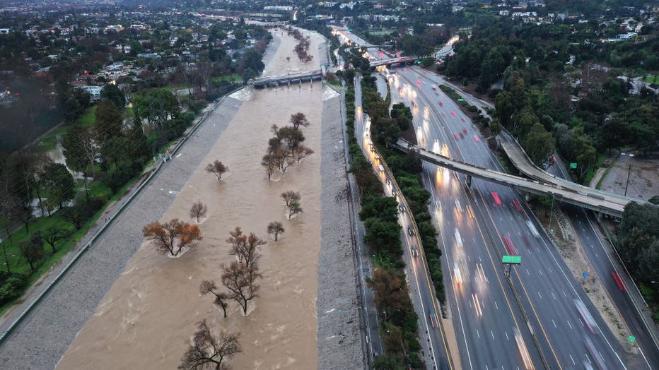
LOS ANGELES - Residents in Southern California continue to deal with persistent rainfall Tuesday after the latest atmospheric river pounded the region and turned deadly, leaving others displaced as the storm damaged their homes.
Along with constant and widespread moderate to heavy rain, howling winds and catastrophic flash flooding continue to factor into the forecast, meteorologists warned.
Since the storm began, LA City officials reported 475 mudslides, 390 fallen trees, 441 potholes, and several water rescues have been conducted.
On Monday, Los Angeles Mayor Karen Bass declared a local state of emergency to ensure the proper resources for the duration of the storm and its aftermath. The day prior, Gov. Gavin Newsom also declared a state of emergency for eight California counties.
President Joe Biden also offered federal aid during a news conference Monday evening.
During a press conference Tuesday, Mayor Bass confirmed there have been no local fatalities so far as a result of this storm. She also advised all residents to check on neighbors, especially the elderly and vulnerable, and remain off the roads when possible.

Mayor Bass gives update on historic storm
Los Angeles leaders held a press conference Tuesday morning to give the latest update on the cit's response and damages amid the historic storm pummeling Southern California.
The Southland was in the bull’s-eye where forecasters believe the risk of flooding is highest. NOAA’s Weather Prediction Center (WPC) placed about 14 million people in the area under a rare "high risk" of flash flooding on Monday. See a gallery of the damage from the relentless storm below.
PREVIOUS COVERAGE:
- California storm turns deadly after trees fall on multiple homes
- California storm: LA Mayor issues local state of emergency as atmospheric river pounds region
- President Biden calls Mayor Karen Bass during LA storm briefing to offer federal assistance
- California storm update: Newsom declares state of emergency
The WPC noted the ongoing situation will continue to produce locally catastrophic flash and urban flooding in the Los Angeles area through Tuesday.
Los Angeles Fire Department Chief Kristin Crowley said the city has responded to the following incidents so far amid the storm: 307 mudslides; 35 incidents of buildings requiring inspection due to mudslides and slope failures; 5 buildings red-tagged; 7 buildings yellow-tagged.

LA city officials provide storm update
Los Angeles City officials provided a storm update on Tuesday, Feb. 6 as a relentless atmospheric river continues to slam the area.
The La Tuna Canyon evacuation order was lifted Tuesday evening and residents are allowed to return home, Crowley said. An evacuation order in the Topanga area near Santa Maria Road was downgraded to an evacuation warning Tuesday afternoon.
The Los Angeles Department of Water and Power is reporting 9,273 customers without power, while 26,310 customers have already had power restored.
Meanwhile, the Department of Public Works has responded to 257 reports of fallen trees and branches in the area and 159 reports of potholes, which street services will be working to fill today, Crowley added.
Historic amounts of rain continue to fall on the Golden State, far exceeding their monthly averages.
(Getty Images)
More on what to expect below.

Weather Forecast for Tuesday, Feb. 6
The latest forecast and air quality conditions for the greater Los Angeles area, including beaches, valleys and desert regions.
Closures
Due to inclement weather, Knott's Berry Farm is closed Tuesday.
The Panorama Walking Trail in Signal Hill has been closed to all pedestrian traffic due to land erosion, according to the Signal Hill Police Department.
Disneyland Resort is closing early to host its "After Drak Sweethearts' Nite" event, which starts at 9 p.m.
Disney California Adventure will close at 9 p.m. and Downtown Disney will close at 10 p.m.
Weather Alerts
Flash Flood Watch
Due to heavy rainfall detected in Orange County, the National Weather Service issued a Flash Flood Warning from 9:55 a.m. to 1 p.m. Tuesday.

Silverado Canyon residents prepare for evacuations
A voluntary evacuation was in place in the Silverado Canyon area in Orange County. The community is prone to heavy flooding.
The areas expected to experience flash flooding include Anaheim, Irvine, Oceanside, the west side of Corona, Orange, Temecula, Mission Viejo, Tustin, Yorba Linda, and San Clemente.
Winter Storm Warning
A Winter Storm Warning remains in place in the mountain communities in San Bernardino and Riverside County, which includes Big Bear Lake, Running Springs, and Wrightwood through 10 p.m. Tuesday.
Expected snowfall totals are as follows:
- 4–8 inches for elevations between 6,000 and 7,000 ft.
- 8–16 inches for elevations between 7,000 and 8,000 ft.
- 1-3 ft. for elevations 8,000 ft. and above
Snow levels could drop to 5,000 ft. by Tuesday evening.
The advisory was also in place through 4 a.m. Wednesday in Frazier Park, with anticipated snow accumulations between 12 and 18 inches.
Travel is not recommended at this time.
Flood Watch
A Flood Watch was in effect through 6 a.m. Wednesday in San Bernardino, Orange, and Riverside counties. This includes areas such as Hesperia, Fullerton, Mission Viejo, Big Bear Lake, Lake Arrowhead, Huntington Beach, Santa Ana, Fontana, Anaheim, the San Gorgonio Pass, and the Lucerne Valley.
The advisory was also in place in Ventura and Los Angeles counties through 4 p.m. Tuesday. This applies to areas such as the Catalina and Santa Barbara islands, the San Gabriel Valley, Antelope Valley, Palos Verdes Hills, Santa Clarita Valley, Malibu Coast and San Fernando Valley.
A Flood Watch brings the risk of dangerous flooding with downpours equating to up to one inch per hour.
Coastal Flood Advisory
A Coastal Flood Advisory is in effect from 2 a.m. Wednesday to noon Friday for the Ventura County beaches. Beachgoers are encouraged to remain out of the water.
High Surf Advisory
High surf will also return to Ventura County. A High Surf Advisory goes into place at 2 a.m. Wednesday and will remain in place through noon Friday. NWS officials reported the Doppler radar picked up to 1.5 inches of rain had fallen Tuesday morning.
What’s next?
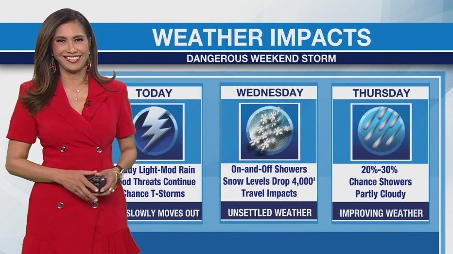
The bulk of the storm will taper off by Wednesday morning with lingering rain chances through Friday. Sunny skies and mild conditions are set to return in time for Super Bowl weekend.
FOX Weather contributed to this report.