

California storm update: Newsom declares state of emergency

California rain causes flooding, evacuations
Gavin Newsom has declared a state of emergency in seven Southern California counties as rain floods roads across Los Angeles County. Evacuations have been ordered in Ventura and LA counties.
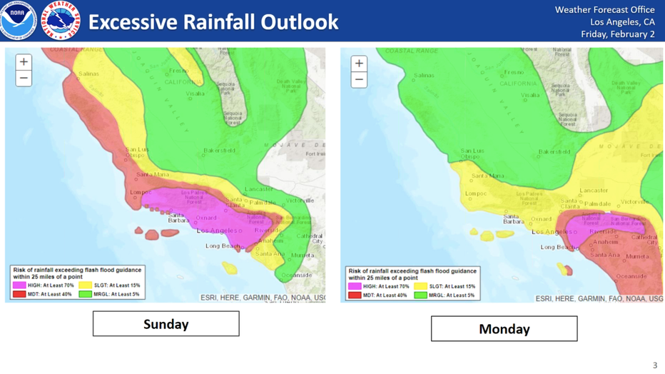
LOS ANGELES - A second much more powerful atmospheric river spanning multiple days moved into Southern California Sunday, creating "life-threatening" flood risks, according to forecasters.
In Los Angeles, there is a rare "high risk" of flash flooding Sunday and Monday due to that atmospheric river, which is promising to dump several inches of rain across the region.
RELATED COVERAGE: California rain: Timeline, evacuations as atmospheric river moves into SoCal
The "high risk" is the highest rung on NOAA's flash flood threat scale and is only issued under the most dire of flooding forecasts.

Flooding forces evacuations in Fryman Canyon
Mud flows have forced the evacuations of multiple homes in Fryman Canyon.
Los Angeles officials urged residents to stay home and off the roads Sunday and Monday, and Gov. Gavin Newsom declared a state of emergency in eight counties in the state, including Los Angeles and Orange counties.
The National Weather Service strongly urges residents to prepare for this "major flooding event," with the storm dropping up to six inches of rain in coastal and valley areas and up to a foot in the mountains. Current weather models predict much of the downpour happening in a 24-to-36 hour span between Sunday night and overnight into Monday.
"Historically, rainfall of this magnitude creates major hydrologic problems in our area and there's no reason to think this won't happen with this event," forecasters said.
Here's what you need to know.
TIMELINE | EVACUATIONS | CLOSURES
Timeline
The powerful atmospheric river is expected to arrive Sunday, forecasters said. A wind advisory in LA County begins at 6 a.m. and the flood watch begins at noon, according to the NWS, and goes through 4 p.m. Tuesday.
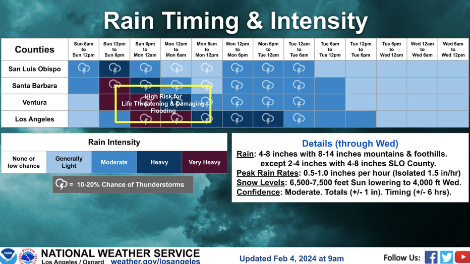
Very heavy rain is expected to hit LA County by 6 p.m., Sunday and continue throughout the rest of the night. Thunderstorms are expected, and potentially life-threatening flash flooding during this time is a top concern for officials.
Further north, heavy rain is expected earlier in the day. Flood watches have been issued for Santa Barbara, Ventura and San Luis Obispo counties through 4 p.m. Tuesday.
SUGGESTED: Cars submerged in water in Long Beach as atmospheric river brings major flooding

Team Coverage: Evacuation orders in California
California Gov. Gavin Newsom has declared a state of emergency in seven Southern California counties. Evacuation orders have been issued in Ventura and Los Angeles Counties.
Evacuations (LA County | Ventura County)
Los Angeles County
Evacuation Orders
- La Tuna Canyon Road area north of Hollywood Burbank Airport (affected area borders Horse Haven Street to the north, Martindale Avenue to the east, Penrose Street to the south, and Ledge Avenue to the west)
- Owen Fire area on Santa Maria Road from Topanga Canyon (now through 6 p.m. Tuesday)
- Agua Fire area along Soledad Canyon Road east of Agua Dulce Canyon Road (now through 6 p.m. Tuesday)
- Fish Fire burn scar area in Duarte on Mel Canyon Road between Fish Canyon Road and Brookridge Road in effect from 6 p.m. Sunday through 10 a.m. Tuesday.
Evacuation Warnings
- Unincorporated Los Angeles County near burn scars from 10 a.m. Sunday through 6 p.m. Tuesday, including the Juniper Hills and Valyermo areas from the Bobcat Fire
- Lake Hughes and King Canyon from the Lake Fire (20000 block of Pine Canyon Road; 18000 block of Ellstree Drive; 46000 block of Kings Canyon Road; 18000 block of Newvale Drive; 43000 block of Lake Hughes Road)
Evacuation Shelters
- Sunland Senior Citizen Center at 8640 Fenwick St. (people and household pets)
- Lake View Terrace Recreation Center at 11075 Foothill Blvd. (people and household pets)
- Large animals can be evacuated to Hansen Dam Horse Park at 11127 Orcas Ave. in Lake View Terrace, and the LA Equestrian Center at 480 Riverside Drive in Burbank
Warnings
- Flash Floor Warnin in central and western LA County until 12 a.m. on Monday, Feb. 5
- High Wind Warning in Antelope Valley in place until 6:30 p.m. Monday
- Flood Watch in the Antelope Valley through Tuesday, Feb. 6
"Do not attempt to travel unless you are fleeing an area subject to flooding or under an evacuation order," the LASD said in a statement.
See a map of all evacuation orders in LA County by tapping or clicking here.
Ventura County
Evacuation Orders
- Matilija Canyon / North Fork / Camino Cielo (Unincorporated Ojai)
Evacuation Warnings
- Ventura RV Resort (City of Ventura)
- Community of Foster Park / Camp Chaffee (Unincorporated Ventura)
- Old Creek Road. / Creek Road (Unincorporated Ojai)
- 4 structures on Grada Avenue & Trueno Avenue (Unincorporated Camarillo)

LA officials discuss city's response to storm
Los Angeles Mayor Karen Bass held a press conference Sunday to discuss the city's response and safety measures being implemented in response to the second atmospheric river battering Southern California.
Evacuation Advisory
- Community of La Conchita
Evacuation Shelters
- Ventura College Gymnasium (4667 Telegraph Road, Ventura, CA 93003)
- For the Owen Fire burn area, a shelter has been established through the American Red Cross at OneGeneration Senior Enrichment Center, 18255 Victory Blvd. in Reseda. For large animals, an animal shelter is available at Agoura Animal Care Center, 29525 Agoura Road in Agoura Hills.
A full map of evacuation orders and more in Ventura County can be found by tapping or clicking here.
Weather Alerts
- Winter Storm Watch is in effect in the eastern San Gabriel Mountains through Tuesday afternoon, with forecasters predicting as much as 2 to 4 feet of snow above 7,000 feet, as much as 20 inches as low as 6,000 feet, and 8 inches at 5,000 feet. Winds will also gust in that area at 80 mph.
- High Surf Advisory issued from 10 p.m. Sunday to 10 p.m. Monday at Orange County beaches, and until 9 p.m. Monday at Los Angeles County beaches
- Flood Watch will be in effect from Sunday afternoon through Tuesday afternoon for Los Angeles and Orange counties
- Flood Advisory issued until 2 pm Sunda for southern Santa Barbara and west Central Ventura counties
Impacts
Officials said downed trees and power lines and power outages are strong possibilities, especially Sunday night into Monday when peak wind gusts are expected.
People are reminded to never touch or try to move downed trees or branches, where power lines may be hidden underneath. Report all downed lines to 911 and PG&E at 1-800-743-5002.
>> TRACK THE RAIN WITH THE FOX 11 INTERACTIVE RADAR <<
The NWS also warned numerous mudslides and debris flows are expected.
"Given the sheer amounts of rainfall expected in the time period, the 3-6 hour rain rates could be problematic, exceeding USGS thresholds, which could lead to mud/debris flow issues as well as swift water rescues in the local rivers and streams," the NWS said.
Additionally, there is a growing potential for brief tornadoes, waterspouts, and damaging wind gusts Sunday for coasts, valleys, and coastal waters of Southwest California, according to the latest forecast.
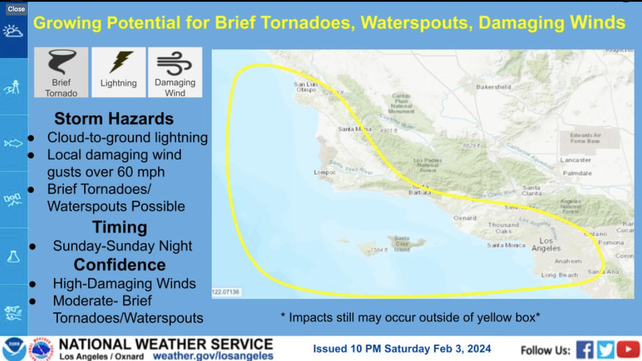
Graphic courtesy National Weather Service
People are strongly advised to stay off the roads, if possible, between Sunday and Monday morning. Freeways are going to be a mess for Monday morning's commute, so forecasters urge those who can work from home to do so as major flooding is possible.
School Closures
Los Angeles Unified School District officials said they would be in touch with parents if any campuses should need to close.
LAUSD Superintendent Alberto Carvalho said the district tentatively plans to keep schools open on Monday, except Vinedale Elementary School in Sun Valley. District officials will continue to monitor the storm, and plans could change later Sunday evening.
"Los Angeles Unified teams from across the District have been planning and preparing for this inclement weather system. Schools are equipped with emergency preparedness plans should campuses experience leaks, flooding or wind damage," the LAUSD said in a statement. "The District is also prepared with alternate plans for impacted areas. We will be in direct contact with families if schools are affected, and the Los Angeles Unified parent hotline is available Monday through Friday from 7:30 a.m. to 5:00 p.m. at 213-443-1300 for families who may have questions or need additional support."
Parents should check with their child's specific school district's social media pages for the latest updates.
The following schools also announced they'd be closed Monday:
- Brentwood School
- Harvard-Westlake School
- Windward School
- New West Charter School
- Notre Dame High School
- St. Paul the Apostle Catholic School
Cal State Fullerton will pivot to remote classes on Monday due to the storm. Staff are encouraged to work remotely, according to school officials.
Other Closures, Cancelations
- Six Flags Magic Mountain will be closed Sunday
- Getty Center and Villa closed Sunday and Monday
- Los Angeles Zoo closed Monday
- All LA County Parks sites (regional parks, nature centers, trails, natural areas, tree farm)
- Santa Anita Park eight-race program rescheduled for Feb. 10.
Transportation Updates
As of Sunday afternoon, LA Metro said it has implemented its inclement weather safety plan and crews are ready to provide rapid response if any issues develop.
Metro ambassadors have also been deployed to all hubs to inform passengers of any transit issues. Anyone with questions can call 323-GO-METRO.
Anticipated Rain, Snow Totals
The Los Angeles metro area may see 5 inches or more by the middle of the week. Los Angeles only averages just over 14 inches of rain per year. As mentioned earlier, the surrounding mountains and their foothills could see 10-12 inches of rain.
Snow levels are expected to be around 7,000 feet, but above that level, 2-4 feet of snow is possible.
Looking Ahead
The wet weather pattern will continue into Tuesday evening, with periods of rain anticipated to continue.
SUGGESTED: California's 'ARkStorm': Historic 1000-year floods of 1861-62 featured 8 weeks of atmospheric rivers
Drier conditions are expected by Wednesday, but a chance of showers will still linger. Snow levels could fall as low as 3,500 feet by Thursday, forecasters said.
City News Service and FOX Weather contributed to this report.