

Los Angeles issues evacuation warning for burn scars as storm threatens mudslides
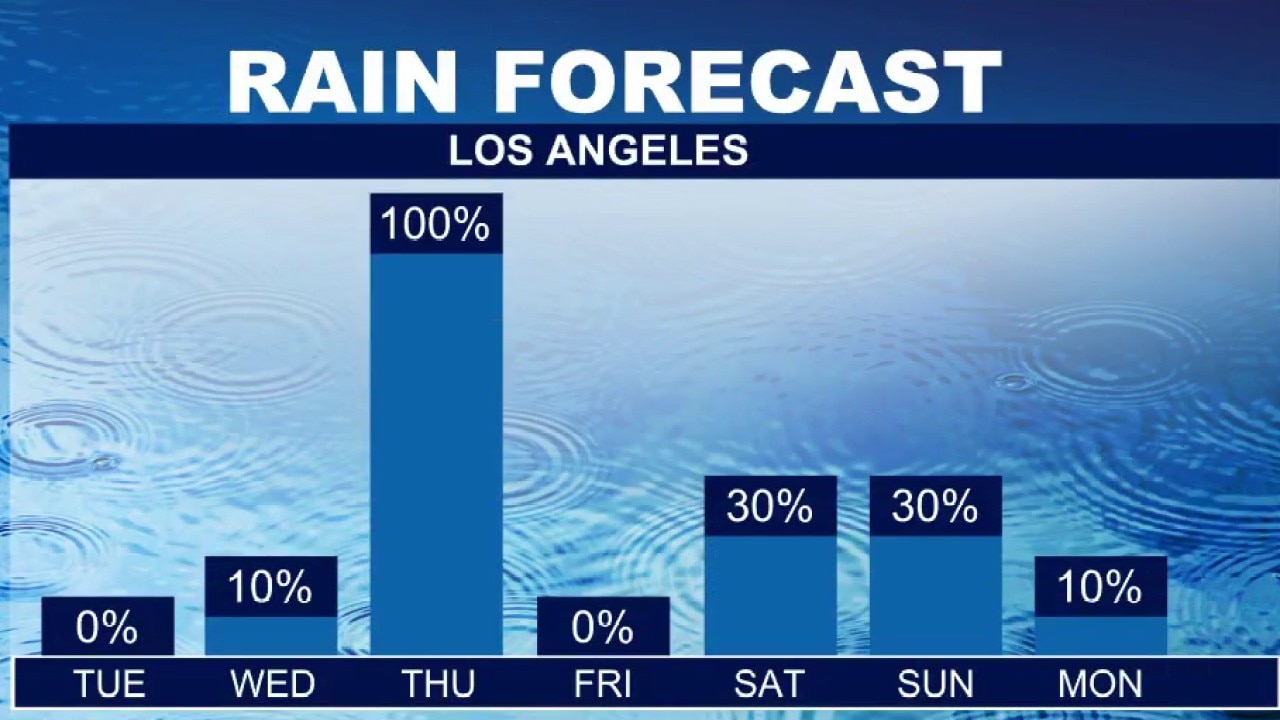
Atmospheric river hits Southern California this week
Southern California is preparing for its first atmospheric river storm of the season this week, which is expected to bring widespread rain, gusty winds, and potential flooding impacts across the region.
LOS ANGELES - The city of Los Angeles has issued an evacuation warning for residents near the Palisades, Hurst, and Sunset fire burn scars due to the threat of mud and debris flows.
Los Angeles Fire Department officials urge residents to prepare to leave, while Los Angeles Police Department officers will visit homes considered to be at particularly high risk.
What we know:
Evacuation warning in effect
Officials urge residents in the following zones to prepare for evacuations due to possible debris flow from 6 p.m. Wednesday until 8 a.m. Friday: LFD-1081, 1083, 1085, 1087, 1089, 1091, 1092, 1093, 1095, 1096, 1097 (Palisades); 0891 (Mandeville); 0001-B (Hurst); 0835 (Sunset).
Residents in high-risk homes will be visited by LAPD officers.
You can view a map of all the latest evacuations below:
First atmospheric river of the season
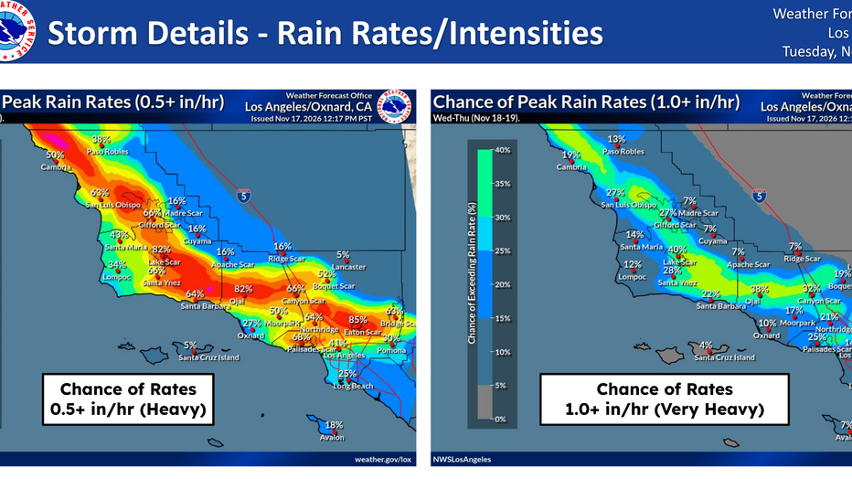
Los Angeles County is expected to bear the brunt of the season's first atmospheric river, with the National Weather Service forecasting 1 to 3 inches of rain for most areas and isolated totals reaching up to 5 inches along south-facing mountain slopes and foothills.
Graphic courtesy of National Weather Service
Wind will enhance rainfall over the mountains, pushing widespread rain rates to a half-inch per hour and localized rates to between 0.75 and 1 inch per hour, the NWS said.
Forecasters warn there is at least a 15% chance of excessive rainfall capable of causing urban roadway flooding, canyon road rockslides, and debris flows near recent burn scars, alongside possible thunderstorms bringing downpours, gusty winds, and lightning.
Flood watch issued
A Flood Watch has been issued for much of Los Angeles County from Thursday morning through Thursday afternoon, covering downtown Los Angeles, the county's beaches and inland coast, the Santa Clarita and San Gabriel valleys, the Santa Monica and San Gabriel mountains, the San Fernando Valley, the 5 Freeway corridor, and the Palos Verdes Hills.
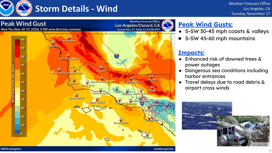
Strong winds will accompany the storm, bringing gusts of 30 to 45 mph across Los Angeles County—which could prompt a wind advisory—and gusts of 25 to 30 mph across Orange County coastal and valley areas.
Graphic courtesy of National Weather Service
Strong winds will accompany the system, with gusts of 30 to 45 mph possible across Los Angeles County—potentially prompting a wind advisory—and gusts of 25 to 30 mph across Orange County coastal and valley areas.
Graphic courtesy of National Weather Service
High Surf Advisory in effect
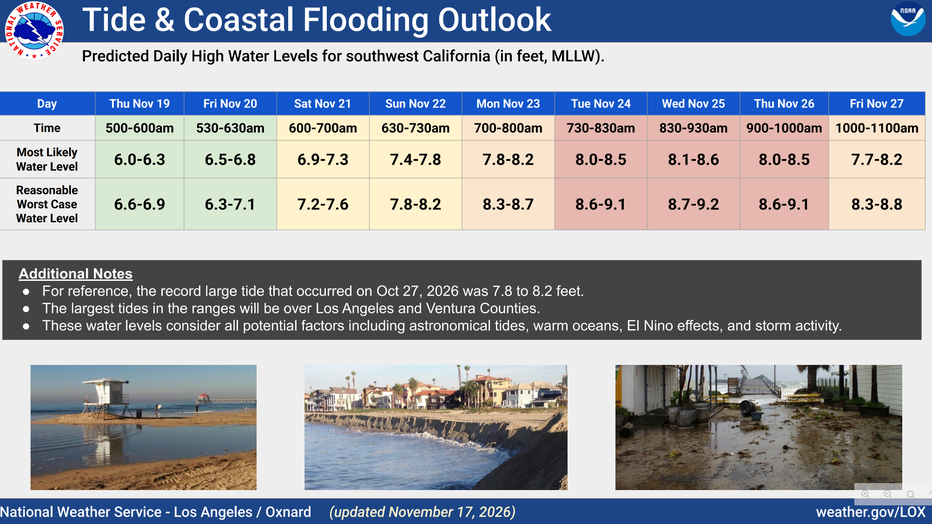
Along the coast, a High Surf Advisory is in effect as large surf and dangerous rip currents continue.
While surf is expected to ease through Wednesday morning, a larger swell arriving late Wednesday night and Thursday could cause minor to moderate coastal flooding near Thursday morning's high tide, pushing seawater over low-lying beaches, walkways, and parking lots while causing significant beach erosion.
Mountain snow
In the mountains, snow levels are expected to remain above 9,000 feet for much of the storm before dropping to around 7,000 feet behind the front, bringing 3 to 8 inches of snow at higher elevations.
Timeline:
Rain timing
Rain is expected to hold off in Los Angeles County until 10 p.m. or later Wednesday night, with the heaviest rainfall rates arriving Thursday morning and early afternoon.
Moderate to heavy rain and a chance of thunderstorms will continue through Thursday night or early Friday, while coastal hazards and enhanced surf peak on Thursday into Friday.
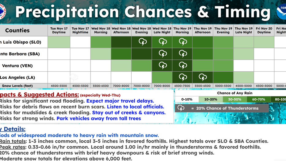
Graphic courtesy of National Weather Service
Conditions are expected to turn dry and cool on Friday with daytime highs mainly in the 60s at lower elevations, though forecasters noted another, weaker storm system could arrive Sunday night or Monday.
What they're saying:
LAFD officials say residents in the Palisades, Hurst, and Sunset burn scar areas should be prepared to evacuate due to the threat of mud or debris flows.
Meanwhile, weather officials are emphasizing the potential severity of the arriving system and urging residents to prepare for widespread impacts.
"This storm is packing quite a punch," the NWS said.
Regarding the broader hazards and seasonal significance of the weather event, the agency added, "There is a risk for significant impacts with the low pressure system arriving mid-week, including flooding and thunderstorms," and noted, "This could be the first storm of the season with truly widespread moderate to heavy rain and high elevation mountain snow."
What you can do:
Residents living near the Palisades, Hurst, and Sunset fire burn scars should prepare to evacuate immediately if conditions worsen or if orders are issued.
Because strong winds combined with rain-soaked soil could topple trees and cause power outages, the NWS advises residents to avoid parking beneath trees and to secure heavy patio furniture.
Forecasters also urge beachgoers to stay completely out of the water or remain near occupied lifeguard towers due to dangerous swimming conditions and strong rip currents, while asking all residents and visitors to closely monitor updated forecasts and local advisories ahead of potentially higher tides during Thanksgiving week.
The Source: This report is based on official forecasts, weather advisories, and public safety warnings issued by the National Weather Service. City News Service contributed.