

California weather: Incoming SoCal storm triggers alerts for mountain communities

LOS ANGELES - After a powerful atmospheric river moved out of Southern California, another storm moved in and by Wednesday night, residents in the local mountain communities should brace for even more snow.
RELATED: California storm: As atmospheric river moves out, another storm moves into SoCal
The National Weather Service predicts the fast-moving storm will intensify Wednesday evening and snow levels could drop to 4,000 feet, which would impact travel along the Grapevine.
More on what to expect below.
Weather Alerts for SoCal mountain communities
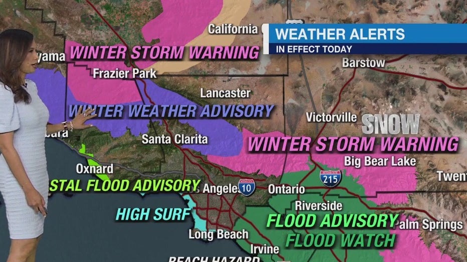
Winter Weather Advisory
A Winter Weather Advisory was in place through 8 a.m. Thursday for mountain communities in Ventura, Los Angeles, and Santa Barbara counties. This impacts areas such as Pyramid Lake, Big Pine Mountain, Rose Valley, the Tejon Pass, Gorman, Topatopa Mountains, Acton and Mill Creek.
The NWS anticipates moderate snow accumulation totals between 2 and 5 inches for elevations of 5,000 feet and up.
In addition, the NWS warns of low visibility during periods of snow that will make for dangerous driving conditions and potential road closures.
Winter Storm Warning
A Winter Storm Warning remains in effect for the San Bernardino County Mountains for elevations above 4,000 feet through 8 a.m. Thursday.
The same area was also under a Flood Watch until 6 a.m. Thursday.

Winter Weather Advisory issued for IE mountains
The National Weather Service issued a Winter Weather Advisory for the San Bernardino County Mountains.
Additional snowfall totals are as follows:
- 2–6 inches for elevations below 5,000 ft.
- 6–10 inches for elevations between 5,000 ft. and 6,000 ft.
- 10–16 inches for elevations between 6,000 and 7,000 ft.
- 16–24 inches for elevations 7,000 and above
Scattered snow showers will continue Wednesday and by the evening hours, winds could gust up to 55 mph.
The same advisory was also in effect in Kern County, including Tehachapi and Frazier Park.
What's next?

Weather Forecast for Wednesday, Feb. 7
The latest forecast and air quality conditions for the greater Los Angeles area, including beaches, valleys and desert regions.
More snow showers were expected through Friday night with the return of sunny skies by Saturday.