

Los Angeles weather: Several areas see major flooding as first of three storms move in

Rain damages Melrose shops
Monday's heavy rain caused flooding at some Melrose shops, damaging their products.
LOS ANGELES - The first of a series of storms came hammering down in Southern California on Monday. Several neighborhoods were soaked by heavy downpours as the National Weather Service (NWS) issued multiple weather alerts in the region.
THIS STORY IS NO LONGER BEING UPDATED. CLICK HERE FOR THE LATEST.
What we know:
Ahead of the storm, the National Weather Service (NWS) advised residents not to make outdoor plans as conditions are expected to be "unusually hazardous."
See a list of updates below.
Three rounds of rain
FOX 11 meteorologist Adam Krueger said the storm will come in waves.
The first wave came Monday. The second wave is expected to hit Tuesday night into Wednesday morning and the final wave will come Thursday.

Long Beach roads turn into rivers
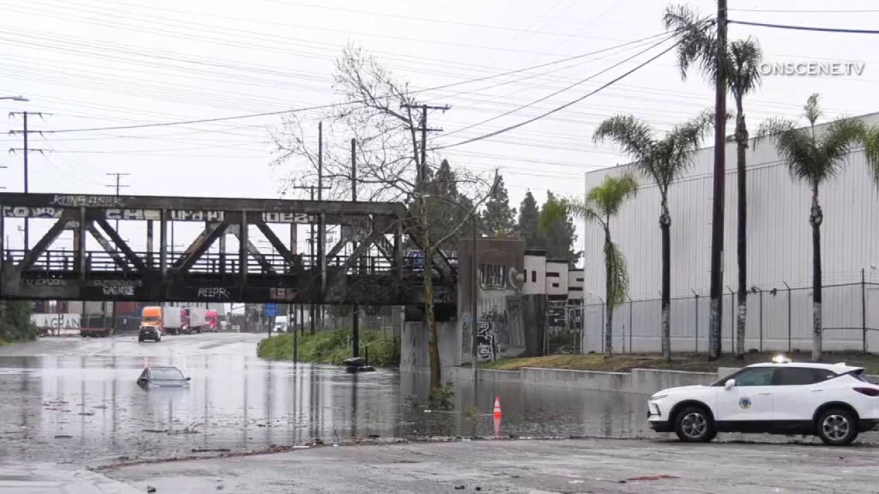
Long Beach sees severe flooding
Some Long Beach streets were turned into rivers as cars got stuck in floodwaters.
Some drivers were stranded in the middle of the road, stuck in high floodwaters. As the storm moved through the area, water quickly spilled into the street and spread across the block. Within minutes, there was flooding. One resident said the overwhelmed storm drains along Lincoln Street near the 710 Freeway couldn’t keep up. Crews also had to shut down a lane on the 710 Freeway to prevent drivers from stalling out in the rising water.
San Fernando Valley flooding
Several areas of the valley saw extreme flooding, including Sun Valley, North Hollywood, Burbank, and San Fernando.
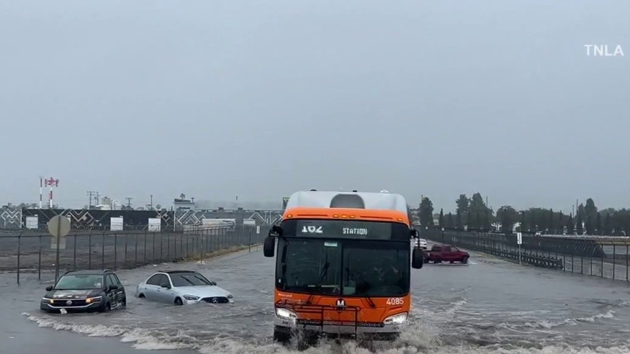
San Fernando Valley sees major flooding as first storm hits
Parts of Sun Valley, North Hollywood, Burbank, and San Fernando saw extreme flooding Monday, causing havoc on the roads.
Ocean Water Advisory
Los Angeles County health officials are warning people to avoid all water contact this week, especially near discharging storm drains, creeks, and rivers, due to potentially higher bacteria levels amid a series of storms. The ocean water quality rain advisory is in effect until at least 8 a.m. Saturday, but may be extended depending on further rainfall, according to the Los Angeles County Department of Public Health.
Flood watch extended
The NWS has extended a flood watch for most of Los Angeles County until midnight Monday evening.
Ground stop at LAX
The Federal Aviation Administration issued a ground stop at the Los Angeles International Airport (LAX) as downpours hammered the area.
Severe Thunderstorm Warning
The NWS issued a severe thunderstorm warning across Los Angeles County through 12:15 p.m. Monday.
Flash Flood Warning
The NWS also issued a Flash Flood Warning through 2 p.m. Monday in several parts of LA County, including the San Gabriel and San Fernando valleys, Whittier, Culver City, Inglewood and Beverly Hills.
Hail and tornadoes are possible
Weather Forecast for Monday, Feb. 16
The latest forecast and air quality conditions for the greater Los Angeles area, including beaches, valleys and desert regions.
"In addition to lightning and thunder, even hail is possible. There's enough energy associated with the system that could also bring in some tornado activity. So we're watching for that as well," said FOX 11's Soumada Khan.
Evacuation warnings

Series of storms headed to Southern California
Southern California braced for a series of powerful storms expected to last through the week.
The Los Angeles Fire Department issued an evacuation warning for the Palisades, Hurst and Sunset fire burn scar zones from 9 p.m. Sunday through 9 a.m. Tuesday.
PREVIOUS: Trio of powerful storms set to drench Southern California starting Sunday: Timeline
Road Closures
Los Angeles County announced proactive road closures and urges residents to prepare ahead of storms and rainfall.
LA County Public Works will implement the following mountain road closures beginning Monday at 10 a.m.:
- Angeles Forest Hwy, from Aliso Canyon Rd to Highway 2
- Big Tujunga Canyon Rd, from Angeles Forest Hwy to Vogel Flat Road
- Upper Big Tujunga Canyon Road, from Angeles Forest to Angeles Crest highways
County authorities said these closures will remain in effect until rainfall subsides and until crews can safely clear debris.
RELATED: Latest Southern California rainfall totals for Feb. 16
In addition, Topanga Canvon Road from Pacific Coast Highway to Grand View Drive closed at 10 p.m. Sunday. "Reopening is dependent on improved weather and road conditions," Caltrans officials said.
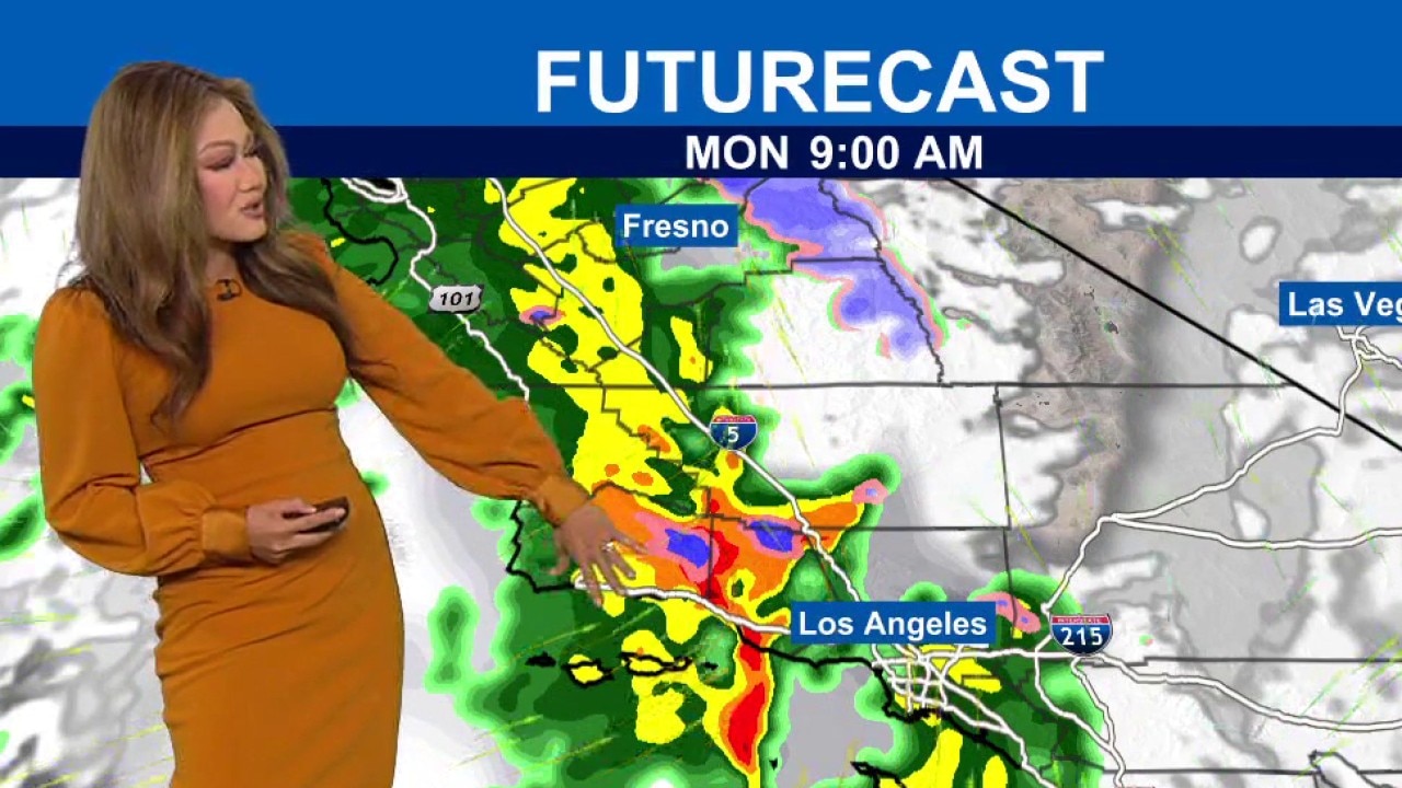
How long will the storms last?
Timeline:
The storm began moving into the region late Sunday night, with the peak of the storm expected Monday through Wednesday. See a timeline below.
Monday, Feb. 16
Rain chances increase significantly beginning Monday morning and continuing into the afternoon commute, with an 80% to 100% chance of rain across the region.
Thunderstorms are possible Monday morning through the evening.
Tuesday, Feb. 17
Heavier rainfall is expected to taper off by Tuesday morning, but residents should prepare for a wet day. Rain is forecast to increase in intensity Tuesday night.
Wednesday, Feb. 18
Another soggy day is expected Wednesday, with a 50% to 70% chance of rain. Rain chances decrease by the evening.
Thursday, Feb. 19
Rain chances drop slightly, but light showers may continue.
Friday, Feb. 20
Rain is also expected Friday, although chances are lower, between 15% and 30%.
How much rain is expected?
The National Weather Service anticipates between 2 and 4 inches of rain along the coast and in the valleys, and between 4 and 8 inches in the mountains and foothills.
What's next:
"We've got a window of opportunity to dry up this weekend. So, after the rainstorm we've gotten more sunshine for Friday and into the weekend," Khan explained.
The Source: FOX 11's Rachel Aragon contributed to this report. This story also used information from the National Weather Service.