

Rain in LA: 1st of 2 atmospheric rivers arrives in Southern California

Winter storm drenches Southern California
The first of two atmospheric rivers pounded Southern California with rain, gusty winds and mountain snow.
LOS ANGELES - The first of two storms has arrived in Southern California, bringing heavy rain, gusty winds, and mountain snow.
RELATED: California storms: Timeline of heavy rain, possible flooding concerns for SoCal this week
The storm made its way into the region late Wednesday night and more widespread rainfall was expected throughout the day on Thursday. Some areas braced for potential flooding, with the National Weather Service (NWS) predicting downpours in certain areas, which prompted them to issue a Flood Watch for a portion of the Southwestern part of the state, including the Inland Empire.
See more details about weather advisories issued by the NWS below.
PREVIOUS COVERAGE: Pineapple Express headed for California with flooding, wind, snow expected this week

Weather Forecast for Thursday, Feb. 1
The latest forecast and air quality conditions for the greater Los Angeles area, including beaches, valleys and desert regions.
Weather Alerts
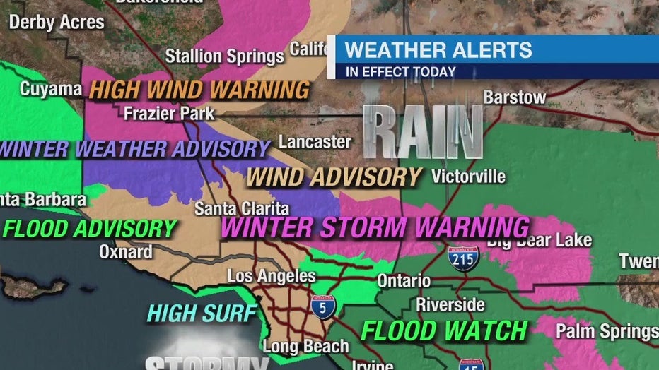
Flood Advisory
A Flood Advisory for the majority of Los Angeles County expired at 10 a.m.
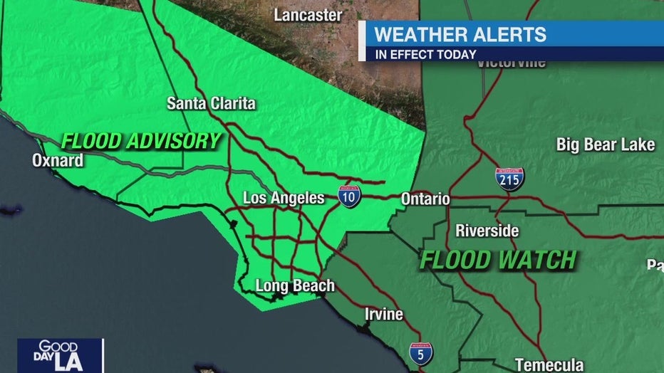
Flood Watch
Due to expected excessive rainfall, a Flood Watch was in effect for several parts of Southern California from 6 a.m. Thursday to 10 a.m. Friday. This includes sections of San Bernardino, Riverside, and, Orange and San Diego counties in cities such as Idyllwild-Pine Cove, Garden Grove, Fontana, Huntington Beach, Corona, Anaheim, Rancho Cucamonga, Crestline, Wrightwood, Fullerton, Ontario, Laguna Beach, Escondido and Santa Ana.
RELATED: Cars submerged in water in Long Beach as atmospheric river brings major flooding
The NWS said the flood threat will fall below the snow level, which is expected between 7,000 and 7,500 feet. Rainfall totals between one-half to three-quarters of an inch per hour are possible.

Arkstorm: What is it and could it hit California?
When Californians think about the big one, it's typically an earthquake. But meteorologists are now debating another extreme weather event that could hit the Golden State... an Arkstorm or ‘’Atmospheric River 1,000 year storm’ that could dump as much as 100 inches of rain on some parts of the state, displacing millions.
Winter Storm Warning
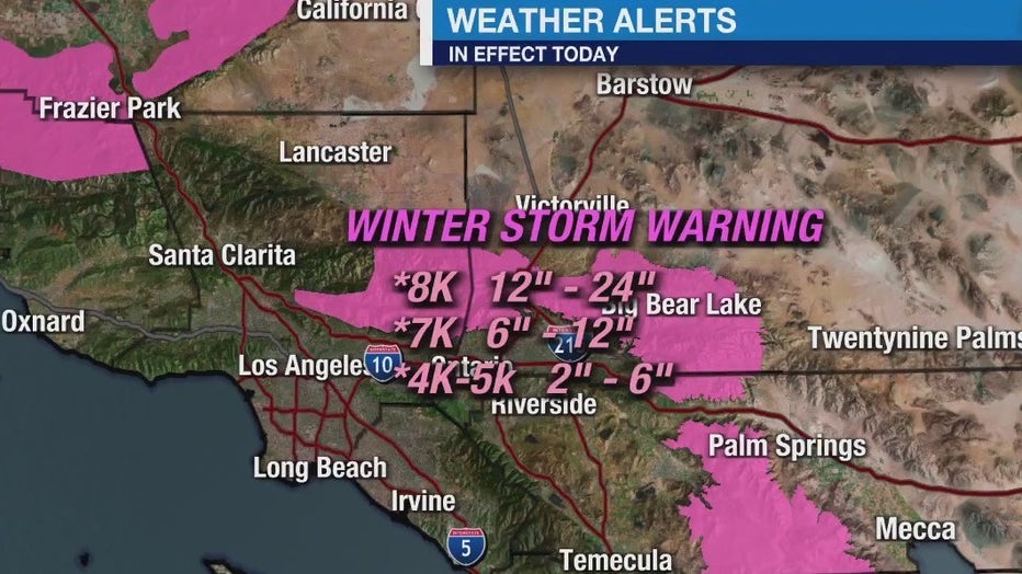
The National Weather Service issued a weather storm warning for the San Bernardino County mountains from 4 a.m. Thursday to 6 a.m. Friday. This includes the areas of Big Bear Lake, Running Springs, and Wrightwood.
The NWS said the combination of gusty winds and heavy snow would pound the area. The expected snowfall accumulation totals are as follows:
- Between 2–6 inches for elevations from 6,000 to 7,000 ft.
- Between 6–12 inches for elevations from 7,000 to 8,000 ft.
- Between 12–24 inches for communities above 8,000 ft.
The NWS forecasts the snow level will rise between 7,000 to 7,500 feet Thursday morning and will drop to 5,000 ft. by Thursday evening.
Only necessary travel is recommended.
Wind Advisory
Winds between 15 and 25 mph with gusts up to 45 mph were possible in the valleys in San Bernardino, Orange, and Riverside counties.
The advisory was in effect in the Inland Empire from 6 a.m. to 2 p.m. Thursday, and from 4 a.m. to noon Thursday in Orange County.
High Surf Advisory
A High Surf Advisory was in effect from 2 a.m. Thursday to 6 a.m. Saturday for beach communities in Ventura, Orange, and Los Angeles County counties, as well as the Malibu Coast.

What’s next?
The storm was expected to taper off by Friday night before a second storm moves into the region by Saturday evening, with rain and mountain snow chances lingering through at least next Thursday.