

California Fires Updates: Saturday, Jan. 18

Los Angeles looks toward wildfire recovery
Los Angeles Mayor Karen Bass announced former police commissioner Steve Soboroff would be the Chief Recovery Officer in the city's efforts to recover from the Palisades and Eaton fires.
LOS ANGELES - Although winds and wildfire concerns have officially passed through Southern California for the week, Angelenos are left with many questions from last week's deadly fires.
What caused the Palisades and Eaton fires? What is the latest in the death toll related to Eaton and Palisades fires?
FOX 11 is keeping tabs on updates provided by local and state officials in hopes of being able to provide the answers to the aforementioned questions.
Follow along below for live updates.
Evacuations continue to lift
5 p.m. — Another evacuation zone related to the Palisades Fire was lifted
- MCR-U021-C: North of Mesa Peak Motorway/Malibu Canyon Road and South of Mulholland Highway/Las Virgenes Road
The latest evacuation maps can be found by tapping or clicking here.
Some roads are still closed. For a list of active road closures, tap or click here.
More Eaton Fire evacuations lifted
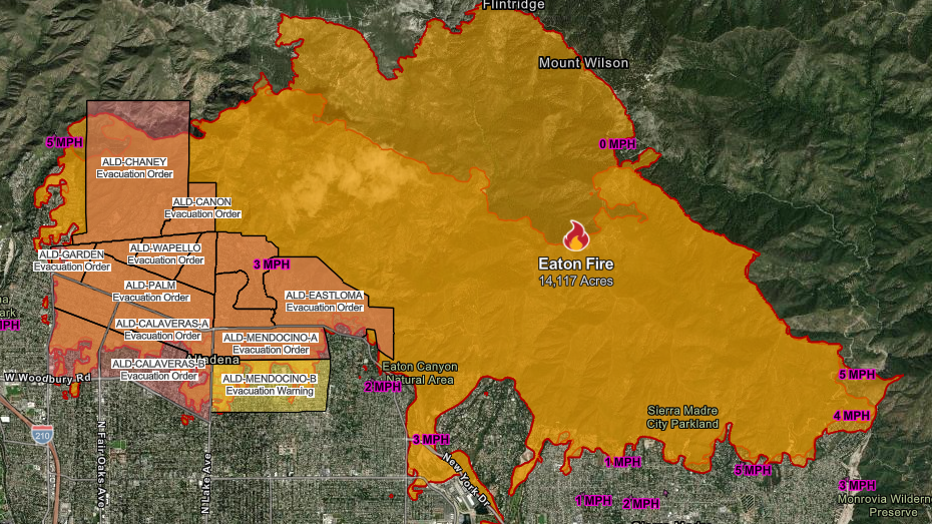
A map of the Eaton Fire and related evacuation areas as of 4 p.m. on Saturday, Jan. 18, 2025. (Cal Fire)
4 p.m. — More evacuations associated with the Eaton Fire were lifted Saturday, including:
- South of Church Canyon Place, east of Old Toll Road, west of SunsetRidge Road
- North of New York Drive, east of Altadena Drive, west of EatonCanyon Trail
- South of Kinclair Drive, east of Kinneloa Canyon Road, west ofEaton Canyon Drive
- Southwest of Altadena Drive, north of New York Drive, east of AllenAvenue
The latest evacuation map for the Eaton Fire can be found by tapping or clicking here.
Officials vow no "conditions" to federal aid
3 p.m. — Federal officials vowed Saturday that they would fight so that any federal funding for wildfire recovery would not come with any conditions, as suggested by officials like House Speaker Mike Johnson.
"California has contributed more to recovery of other states than any other state in the union," said Sen. Adam Schiff. "Always we have been there for every other state. We are going to count on the rest of the United States of America to be there for us."
"In the history of the United States we've never conditioned aid," said Rep. Ted Lieu. "We're fighting to make sure that California disaster victims are treated the same as disaster victims from every other state."
Santa Monica evacuations lifted
12:15 p.m. PT — The City of Santa Monica has lifted all evacuation orders and warnings within city limits. With evacuations lifted, the countywide 6 a.m. - 6 p.m. daily curfew has also ended in Santa Monica.
The latest evacuation map for the Palisades Fire can be found by tapping or clicking here.
Power restoration in Brentwood, Encino
12 p.m. PT — The Los Angeles Department of Water and Power announced that more homes in the Brentwood and Encino areas had their power restored overnight. They now estimate about 1,400 homes in the Brentwood and Encino areas are still without power. Any LADWP customers with questions about their service can call 1-800-342-5397.
Palisades Fire re-entry
9:30 a.m. PT — More evacuation zones related to the Palisades Fire continue to be opened to residents.
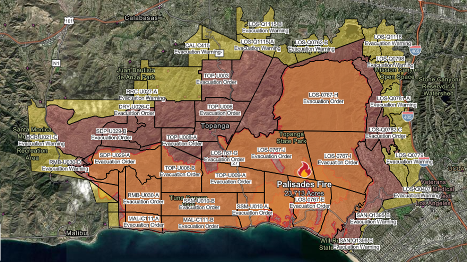
Evacuation orders and warnings associated with the Palisades Fire as of 9:30 a.m. on Saturday, Jan. 18, 2025. (Cal Fire)
The following mandatory evacuation zones have been opened to RESIDENTS ONLY:
- North of Mulholland Dr.; south of Alonzo Ave; east of Mulholland Dr and; west of Mulholland Dr; Escalon Dr Encino Hills Dr.
- North of Arbutus Way, Mandeville Canyon Rd, N Kenter Ave; south of Mulholland Dr, Canyonback Rd.; east of Mandeville Canyon Rd.; and west of Canyonback Rd.
- North of Woodacres Rd, Pacific Coast Hwy; south of Mandeville Canyon Rd, Pesquera Dr, Elkins Rd; eat of Casale Rd; and west of S Cliffwood Ave.
- North of Carrara Pl, Kenfield Ave, N Kenter Ave.; south of N Kenter Ave; east of N Kenter Ave; and west of Mount Saint Marys Fire Rd
The following evacuation warning zones have been opened to RESIDENTS ONLY:
- North of Mission Canyon Road; south of Meadow Ridge Road, Hayvenhurst Avenue; east of Calneva Drive; west of Sepulveda Boulevard, Valley Meadow Place, Royal Oak Road
- North of Standish, Mulholland Drive; south of Adlon Road EAST of Escalon Drive; west of Hayvenhurst Avenue
- North of Canyonback Rd; south of Canyonback Rd, Mission Dump Rd; east of Canyonback Rd; west of Canyonback Rd
- North of San Diego Freeway; south of Mulholland Drive; east of Canyonback Road, Mulholland Drive; west of San Diego Freeway, Mulholland Drive
- North of North Kenter Avenue, Greenock Lane; south of North Kenter Avenue, Sky Lane, Travis Street, North Tigertail Road; east of Access Road for Power Lines; west of Greenock Lane, Travis Street
- North of Promontory Rd, Mount Saint Marys Fire Rd; south of Canyonback Rd, Mission Dump Rd; east of Canyonback Rd; west of I-405 N
- North of Getty Center Dr, Mount Saint Marys Fire Rd, N Bundy Dr; south of Promontory Rd, Mount Saint Marys Fire Rd; east of Mount Saint Marys Fire Rd; west of I-405 N
- North of Canyonback Rd, Mission Dump Rd; south of Park Lane Cir, Mulholland Dr, Sloan Dr; east of Canyonback Rd; west of N Sepulveda Blvd
The latest up-to-date map of the Palisades Fire and associated evacuation orders and warnings can be found by tapping or clicking here.
Anyone hoping for entry into the above evacuation zones must show proof of residence with a photo ID.
More information about the repopulation process in the Palisades Fire area can be found by tapping or clicking here.
Mortgage grace period
9 a.m. PT — California Gov. Gavin Newsom announced "a commitment from major mortgage lenders," to offer of a 90-day grace period for mortgage payments for those affected by the fires.
Fire containment continues to grow
6 a.m. PT — Containment for both the Palisades Fire and the Eaton Fire have increased. The Palisades Fire has burned 23,713 acres and is 43% contained. The Eaton Fire has burned 14,117 acres and is 73% containted. The Auto Fire, Hurst Fire, Lidia Fire, Sunset Fire and Kenneth Fire are all now 100% contained.
The Eaton Fire
The Eaton Fire was first reported on Tuesday, Jan. 7 near Altadena and Midwick drives.
Some residents did not survive the flames and at least 7,000 structures were destroyed.
Authorities have implemented a curfew from 6 p.m. to 6 a.m. for all areas that remain under mandatory evacuation orders in the Altadena area. This comes after more than 30 looting arrests were made by the LA County Sheriff's Department.
The cause of the fire is under investigation, but they were fueled by extreme drought conditions, combined with the supersized Santa Ana winds that whipped flames and embers at 100 mph – much faster than usual.
A lawsuit filed Monday claims Southern California Edison equipment sparked the Eaton Fire.
The lawsuit alleges that Southern California Edison failed to comply with essential electrical and fire safety standards, including failing to maintain power lines and overgrown vegetation.
The Palisades Fire
The Palisades Fire broke out on the afternoon of Tuesday, Jan. 7 as parts of Southern California were hit by powerful Santa Ana winds – the strongest to hit the area in over a decade, officials said. The piercing winds not only intensified the spread of the fire, it also prevented helicopters and planes from dumping water or fire retardant onto the burning scene as it was too dangerous to fly during the first day of the massive fire.
The fire extended well over 23,000 acres in seven days, destroying homes and businesses across the Pacific Palisades and Malibu. The fire also forced evacuations across parts of LA County, including Bel-Air, Brentwood and Santa Monica.
The fire also destroyed the Pacific Palisades Charter High School and other schools in the fire's path.
What caused the Palisades Fire?
The cause of the fire remains under investigation.
According to a report from the Los Angeles Times, a popular hiking destination, Skull Rock – an area north of Sunset Boulevard in Pacific Palisades – is at the center of an investigation "as a possible starting point for the Palisades fire."
Meanwhile, local authorities have announced multiple rounds of arrests taking place from the Palisades Fire scenes, but none of which are explicitly related to the cause of the fire. Over the weekend, there was an announcement of a man arrested for impersonating a firefighter. The alleged "fake firefighter" was accused of trying to break into one of the evacuated homes.
Other people have also been accused of arson across Southern California.