

Triple-digit heat, chance of thunderstorms in California forecast: What to expect

Weather forecast for Thursday, May 29
The latest forecast and air quality conditions for the greater Los Angeles area, including beaches, valleys and desert regions.
LOS ANGELES - Much of California is getting ready for record-breaking temperatures, with a slight chance for showers and thunderstorms in the coming days.
According to the National Weather Service, the surge of warmth is expected statewide on Friday, May 30, with temperatures in some inland areas going near or above 100 degrees.
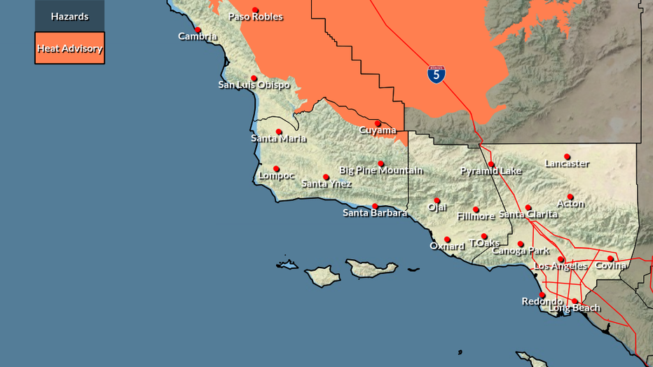
The NWS said triple digits are likely for the Central Valley, with Redding forecast to hit up to 109 degrees on Friday. Bakersfield could see a high of up to 106 degrees. According to the latest forecast, other cities with a chance of breaking record highs include Ojai, Palmdale, and Lancaster.
"There is an increasing chance — 30% to 40% — of Friday’s highs approaching or breaking calendar daytime record(s) across some valley and desert areas," the agency said in its May 27 forecast.
According to the NWS, temperatures in Los Angeles and Orange counties will reach the upper 80s and peak on Friday at around 94 before a gradual cooldown.
Meanwhile, beaches and the coast will see a range of 70s with a slight chance for showers on Saturday and Sunday.
Heat Advisories have been issued Friday for interior San Luis Obispo County, with a 30% chance of advisories for southern valleys. Added portions of Ventura and Los Angeles counties are also under a Heat Advisory, as those areas are expected to be 10 or more degrees above normal.
Showers including thunderstorms will be possible Saturday afternoon through Sunday night, with the greatest chance of precipitation during the afternoons for the San Gabriel Mountains.
The Source: Information for this story is from the National Weather Service.