

More snow expected for California mountains after nightmare blizzard

Blizzard aftermath continues in NorCal
Thousands are finally digging out of more than 6 feet of snow.
Following a day of clearing snow after days of blizzard conditions left anywhere up to 8-10 feet of snow, there is more snow falling in the northern Sierra Nevada snow-stunned mountains of California.
SUGGESTED: California storm: More rain, mountain snow expected
Thousands are still waiting for power to be restored and roads cleared across the Northern California mountains from the monster snowstorm.
While all snow alerts have come down for the Sierra Nevada, another 5-8 inches of snow are possible in the northern Sierra on Tuesday. Total snow forecasts have dropped to a few inches for Interstate 80.
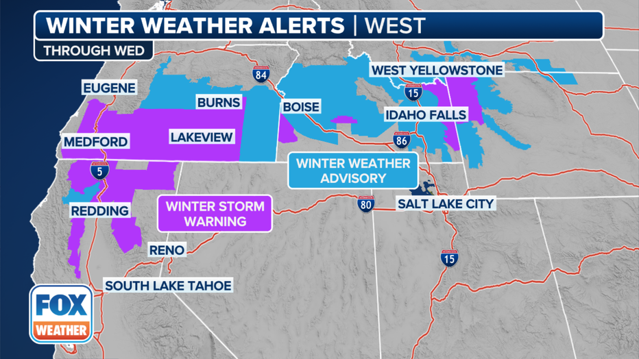
Instead, the heaviest snow will stay north of the Sierra near a stationary front, with the higher elevations of Northern California's Klamath Mountains and Oregon's Cascades picking up as much as 10-18 inches of snow.
Winter Storm Warnings are in effect into Wednesday, the FOX Forecast Center said.
Winter weather alerts are posted across the West.(FOX Weather)
Travel along I-5 could become hazardous, with over 6 inches of snow expected along parts of the route in far northern California and southern Oregon.
While not expected to create near-blizzard conditions, wind gusts to 45 mph will blow around the 8-10 feet of snow that fell over the weekend in the high Sierra and any additional falling snow. Even the Sacramento Valley could see gusts from 25-35 mph.
Meanwhile, areas in the Sierra that were hit hardest by the last storm are missing out on the worst with this one, the FOX Forecast Center said. Those around Lake Tahoe may not see much in the way of accumulation, while up along I-80 in Donner Pass, an additional few inches of snow will fall.
Locals call the heavy, wet snow in the Sierra Nevada "Sierra Cement." That "cement" took its toll on snowplows, taking out all but two of the 10 snowblowers on plows at the Caltrans central hub and leaving six of 20 in total from the California foothills to the Nevada state line.
Heavy snowfall has caused major highways and interstates in Tahoe to be blocked, leaving some people cut off. Crews are gradually allowing passenger cars onto I-80, while another major highway has been cleared, but traffic was occasionally being stopped for spinouts and avalanche control.
While these snow totals will be much less than the previous, more long-lasting storm, travel will remain challenging and the additional heavy snows will exacerbate recovery from the first storm.
The snow will wind down Wednesday as an offshore storm slides south and brings rain to Southern California, including Los Angeles.
Next storm eyes Southern California

Weather Forecast for Tuesday, March 5
The latest forecast and air quality conditions for the greater Los Angeles area, including beaches, valleys and desert regions.
The next storm gearing up in the Pacific Ocean will head south, giving Northern California a much-needed break. Widespread rain will move into Southern California in time for the Wednesday morning commute. Rain amounts aren't too impressive – on the order of a half-inch to an inch – but it doesn't take much rain to snarl a commute.
The Golden State dries out a bit and even warms up during the second half of the workweek before the next storm begins to develop off the West Coast during the upcoming weekend.
Get updates at FOXWeather.com.