

Heat Advisory issued as first Santa Ana winds bring critical fire danger to Southern California
Weather Forecast for Monday, Oct. 27
The latest forecast and air quality conditions for the greater Los Angeles area, including beaches, valleys and desert regions.
LOS ANGELES - Southern California is preparing for its first Santa Ana wind event of the fall season, bringing elevated fire-weather conditions, unseasonably high temperatures, and very low humidity from Tuesday through Wednesday.
Heat Advisory issued
Timeline:
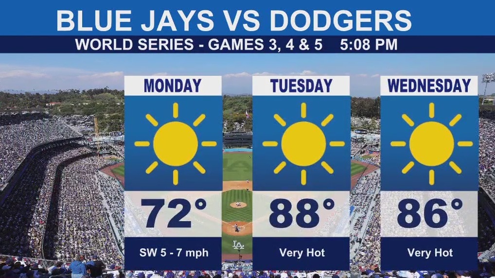
Monday: Warm and moderately dry conditions continue across the interior. Gusty northwest to north winds are widespread across wind-prone mountains and deserts, according to the National Weather Service. A drying trend on Monday leads to elevated fire-weather conditions in these areas.
Tuesday: The first Santa Ana wind event of fall begins, bringing an abrupt warming and drying trend. Temperatures are expected to climb into the 80s to lower 90s, with humidity falling to between 10 and 20% (possibly as low as 5 to 10% in isolated areas). Wind gusts of 30 to 40 mph are likely across eastern Ventura and western Los Angeles counties, with isolated gusts up to 45 mph. This combination results in elevated to brief critical fire weather conditions. Coastal areas will likely see their warmest day today.
High temperatures for Orange County and portions of the valleys will warm as much as 10 to 15 degrees, with up to another 5 degrees of warming on Wednesday depending on location.
Wednesday: Offshore winds are expected to weaken slightly, but a second round of Santa Ana winds is possible, though not anticipated to be as strong as Tuesday's. Interior areas may experience their warmest day today.
High temperatures for inland Orange County will range from the lower to mid 90s.
Thursday through Saturday: A lingering offshore wind influence maintains warm and dry conditions across the interior. Temperatures will cool slightly as the sea breeze returns Thursday, but temperatures will still remain well above normal, the NWS said.
Critical fire danger
What we know:
A significant warming trend, which began Monday, is expected to last through late in the week, driven by the first Santa Ana wind event of the season.
High temperatures will reach the 80s to low 90s across the four counties, which is 10 to 15 degrees above normal for this time of year.
Coastal areas of Los Angeles and Ventura counties, including Malibu, Pacific Palisades, Long Beach, Torrance, Beverly Hills, and Hollywood, are among the areas affected.
A Heat Advisory has been issued for Tuesday and Wednesday for much of the region including Los Angeles, Ventura, and Orange counties as well as inland valleys.
What's next:
The ridge of high pressure will remain in place through next weekend, keeping temperatures well above normal throughout the extended period.
There will be slight cooling Thursday and Friday, but the latest forecast models show another potential warm-up for the weekend.
What you can do:
Anyone planning outdoor activities during the peak days of Tuesday and Wednesday, including attending the World Series at Dodger Stadium, should be prepared for unusually hot and dry conditions.
With the Heat Advisory in effect, residents should take precautions against the heat and be mindful of the elevated fire risk due to the gusty winds and extremely low humidity.
The Source: Information for this story is from the National Weather Service.