

California rain timeline: Significant storm forecast over 4-day period

Weather Forecast for Friday, Jan. 19
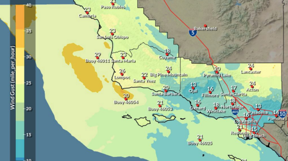
The latest forecast and air quality conditions for the greater Los Angeles area, including beaches, valleys and desert regions.
LOS ANGELES - Get ready not to see the sun for a while, the National Weather Service is warning Californians.
The stark message comes shortly before two to three storms are expected to hit Southern California, bringing the potential for significant rain, gusty winds, and a slight chance of thunderstorms over four days, beginning over the weekend, according to the latest forecast.
"Periods of rain, potentially heavy at times, will be possible across most of the area late Friday through Monday," the NWS said. "Don’t expect to see the sun for a while as Southern California enters into a cloudy and increasingly wet period."

4-day storm headed to SoCal
Get ready not to see the sun for a while, the National Weather Service is warning Californians.
The brunt of the storm is expected to batter the region Friday through Monday, bringing flood-related impacts to certain areas. Additionally, there is a 40-50% chance of elevated to high surf and minor coastal flooding for all west-facing beaches Saturday and Sunday, which may continue through the middle of next week.
For the Inland Empire, rain chances begin Friday through Monday night, with heavy rain expected Monday with a 90% chance of showers.
In Los Angeles County, rain chances begin Friday night and will linger possibly through Tuesday. The highest chances for rain are Saturday night, Sunday night, and Monday.
In Orange County, the chance for potentially more significant rainfall will be on Monday, with chances for one inch or more of rainfall in portions of the mountains nearly 80% and more than 50% for the rest of the county.
Ventura County rain chances begin Friday night as well, with the highest likelihood of rain occurring Saturday night, Sunday night, and Monday.
The region will see the quietest portions of the wet weekend Sunday morning and most of Sunday afternoon, according to the NWS.
Timeline
- Friday night through Saturday night for Central Coast: Light rain
- Saturday morning through Saturday night elsewhere: Light rain
- Sunday all areas: Light rain
- Sunday night through Monday all areas: Moderate to heavy rainfall rates
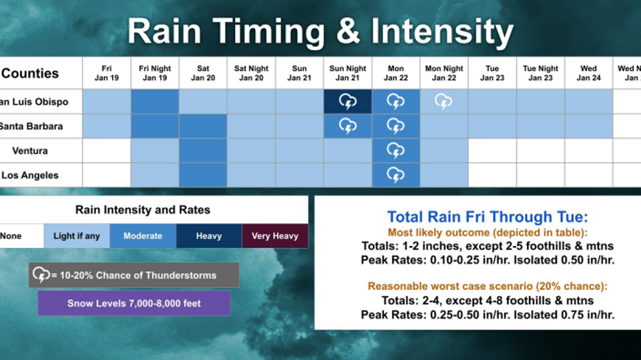
"The system takes a little breather Saturday and Saturday night," forecasters said. "There will still be plenty of moisture ... but there will also be some significant dry intervals as well."
"The most organized, most dynamic and most moisture fed storm will move into the area Sunday night and continue through Monday afternoon," forecasters said.
Impacts
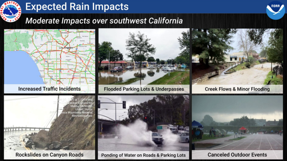
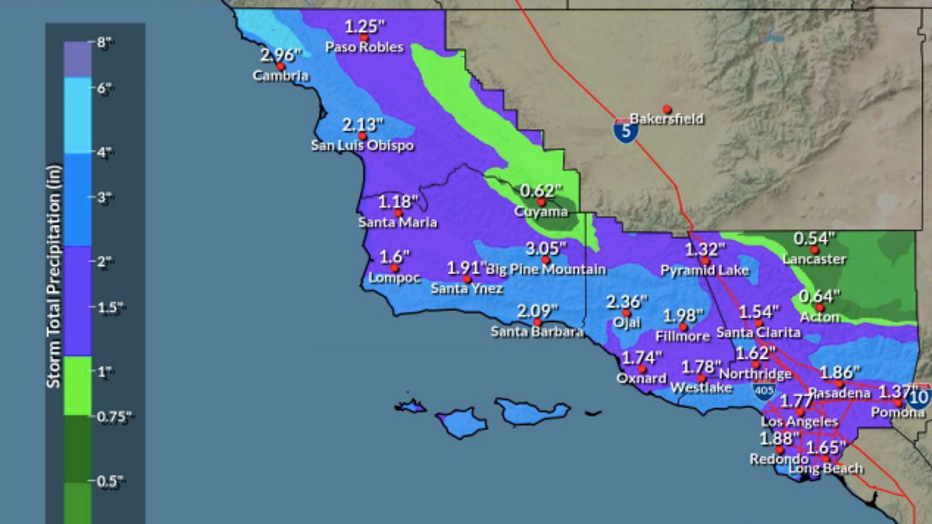
According to the latest models, around 1 to 2 inches of rain is likely, except for the foothills and mountains where up to 5 inches is possible.
Rain
- Minor roadway ponding, with flowing water in sensitive drainages expected Sunday night through Monday
- Difficult commute conditions, with higher incident rates are expected
- Minor flooding of small streams and urban areas will be possible in the most likely scenario
- More significant flooding possible in the reasonable worst-case scenario
- Rocks/debris on canyon roadways
- Reduced visibility due to rain will be hazardous to mariners
- Moderate and heavy rain with gusty winds can reduce visibilities and create dangerous boating conditions
Wind
- Hazardous crosswinds, especially for high-profile vehicles Sunday night-Monday
- Hazardous boating conditions on area waters due to strong winds and increased wave activity Friday through Monday
- Power outages possible
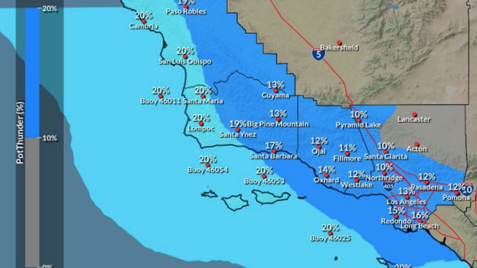
Thunderstorms
- Dangerous lightning activity, especially for those enjoying outdoor recreation; locally heavy rainfall rates, especially Monday
High Surf
- Strong rip currents will create dangerous conditions on rock jetties Saturday through Tuesday
Storm Totals
"There is still a chance that this storm could overproduce," forecasters cautioned, as a number of computer models show rain totals of 1 to 3 inches.
Snow levels
Snow levels will be over 7000 feet, with no significant snow impacts expected, according to the NWS.
"Not expecting much in the way of snow impacts as snow levels are even higher," forecasters said.
Between 6-12 inches is possible above resort levels.
When will it stop raining?
According to the latest forecast models, the chance of rain diminishes Monday night, with the highest chance of rain still lingering over LA County. But by Tuesday, all rain should have moved out of LA County.
"The chance of rain will diminish Monday night with the highest chance of rain over L.A. county," according to the NWS.
High pressure then builds for the rest of the week, bringing dry conditions and a warming trend with above normal temperatures slated for next Thursday, the NWS said.
City News Service contributed to this report.