

Rain, low-elevation snow hit SoCal as cold spring storm moves in

Cold storm drops snow level to 3,000 ft.
It may be spring but on Friday, it feels more like winter in Southern California.
LOS ANGELES - It may be the beginning of spring, but a cold storm has arrived in Southern California, bringing winter-like conditions to the region.
The system began moving into the area late Thursday night with widespread rain and low-elevation snow.
"It just depends on where you are this morning and certainly the remainder of today. Depending on your location, you’re either going to get just some light showers, none at all, or maybe a heavy downpour," FOX 11 Meteorologist Maria Quiban explained.
She added the storm is unstable and as it moves in, thunderstorm chances are possible.
For the mountain communities, snowfall was expected at elevations of 3,000 feet and above. For those traveling along the Grapevine, "showers and storms are expected to taper off Friday night, though
there is a 15% chance of light snow showers over the north-facing mountains near the Grapevine through early Saturday,'' forecasters said.
The estimated snowfall amounts were:
- Between 8 and 12 inches for elevations of 6,000 ft. and above
- Between 3 and 6 inches for elevations of 5,000 – 6,000 ft.
- Up to 3 inches for elevations above 3,000 ft.
Temperatures in the mountains will drop to as low as 20 degrees overnight, while afternoon highs will hover in the low to mid-50s for the inland and coastal communities.
SUGGESTED: Newport Beach landslide: 3 homes flagged by officials

People walk in the rain on Hollywood Boulevard. (Photo by Mario Tama/Getty Images) (Getty Images)
PREVIOUS COVERAGE: California storm returns: Here's what to expect

Weather Forecast for Friday, April 5
The latest forecast and air quality conditions for the greater Los Angeles area, including beaches, valleys and desert regions.
Weather Alerts
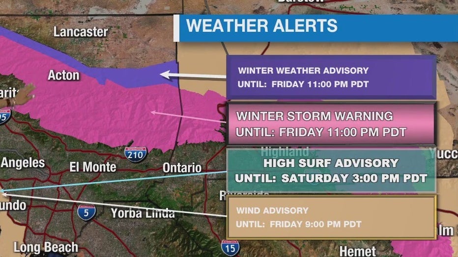
The following weather alerts have been issued by the National Weather Service (NWS).
Winter Storm Warning
A Winter Storm Warning is in effect in the mountain communities in San Bernardino and Riverside counties until 11 p.m. Friday.
Wind Advisory
A Wind Advisory is in place from noon to 9 p.m. Friday with west winds potentially gusting up to 40 mph. This applies to beaches in Ventura and Los Angeles counties, the Malibu coast, and Palos Verdes Hills.
High Surf Advisory
A High Surf Advisory remains in effect through 3 p.m. Saturday. The NWS warns of strong rip currents and large breaking waves of 7 to 10 feet, with local sets to 12 feet on wet-facing beaches.
Beach Hazards Statement
The NWS warns of breaking waves of 4 to 6 feet along the Orange County Coast. There is a possibility of lightning strikes Friday afternoon and evening and the NWS warned people to remain out of the water due to dangerous swimming conditions. This remains through 8 a.m. Saturday.
Will it rain all weekend?
The good news is this is a fast-moving storm that will begin to taper off late Friday into early Saturday. Saturday and Sunday bring cooler temperatures and sunny skies before a warming trend begins early next week.