

California Fires Updates: Monday, Jan. 20

Sister of Hawkins House of Burgers loses home to fire
The home belonging to the sister of Hawkins House of Burger's owner burned down during the Eaton Fire in Altadena.
LOS ANGELES - As critical fire weather conditions return to Southern California Monday, firefighters are working around the clock to gain as much containment as possible for the Eaton and Palisades fires.
Over the weekend, several evacuation orders were lifted for more than a dozen areas, including Altadena communities impacted by the Eaton Fire. Santa Monica officials also lifted all evacuation orders in the city, and Pacific Coast Highway is now accessible for local residents, businesses and patrons.
Crews also continue to investigate the cause of the Palisades and Eaton fires, as well as other fires that erupted in Southern California over the last few weeks, like the Sunset Fire, the Hurst Fire, the Auto Fire and the Lidia Fire.
President Donald Trump said that he will travel to Los Angeles on Friday to view the wildfire damage.

Some homes still standing, others destroyed in fires
More residents saw the devastation first-hand as more evacuation orders were lifted over the weekend.
SUGGESTED: LA Weather timeline: Santa Ana winds to return this week
Follow along below for live updates.
Chambers Fire
7:55 p.m.: A fire broke out in Hemet, but officials say forward progress has since been stopped.
Eaton Fire
6:30 p.m.: Containment of the 14,000-acre fire has improved to 87%.
Palisades Fire
6:00 p.m.: Containment of the 23,000-acre fire has improved to 61%.
Fire on freeway
4:48 p.m.: LAFD says the fire along the 405 Freeway near Granada Hills has since been contained.
4:30 p.m.: A fire breaks out along the 405 Freeway near Granada Hills, severely delaying traffic.

Fire near 405 Freeway
Crews are battling a small fire near the 405 Freeway in Los Angeles' San Fernando Valley.
Arson suspect arrested
3:30 p.m.: An arson suspect has been arrested in the Griffith Park Fire.
Latest numbers on Palisades Fire
3:00 p.m.: During a press conference, assistant fire chief Joe Everett gave an update on the current operational response to the Palisades Fire.
- 23,713 acres burned, 59% contained
- 5,175 personnel assigned to firefight, including 496 engines and 39 helicopters.
- 6,051 structures were damaged. Of those, 4,964 are homes.
- 24,600 people remain evacuated. Since yesterday, 3,827 people have returned home.
- 75% of the area has been surveyed for damage.
- 15 search and rescue teams continue to search the area. 95% of their work is complete.
- The cause of the fire is still not known and under investigation by the ATF.

Palisades Fire update: Containment reaches 59%
Southern California is bracing for another round of powerful, sweeping winds in and around Los Angeles.
Fire erupts near San Diego
2:25 p.m.: Firefighters battled the Ted Williams Fire that broke out near Poway. The fire is currently two acres and is threatening structures, according to Cal Fire. The San Diego County Sheriff's Department has issued Evacuation Warnings for nearby areas. Firefighters gained control and quickly knocked down the flames.

Firefighters battle fire north of San Diego
Firefighters are battling the Ted Williams Fire that broke out near Poway. The fire is currently two acres and is threatening structures, according to Cal Fire. The San Diego County Sheriff's Department has issued Evacuation Warnings for nearby areas.
Trump mentions wildfires in inauguration speech
2:22 p.m.: During his inauguration speech, President Trump made comments about the wildfires burning in Los Angeles County.
"Los Angeles, where we are watching fires still tragically burn from weeks ago without even a token of defense," Trump said in part.
RELATED: Newsom responds to Trump's criticism of California in inauguration speech

Trump comments on LA fires during speech
During his inauguration speech, Donald Trump commented on the wildfires in LA, saying the state doesn't have a "token of defense" as the fires rage on.
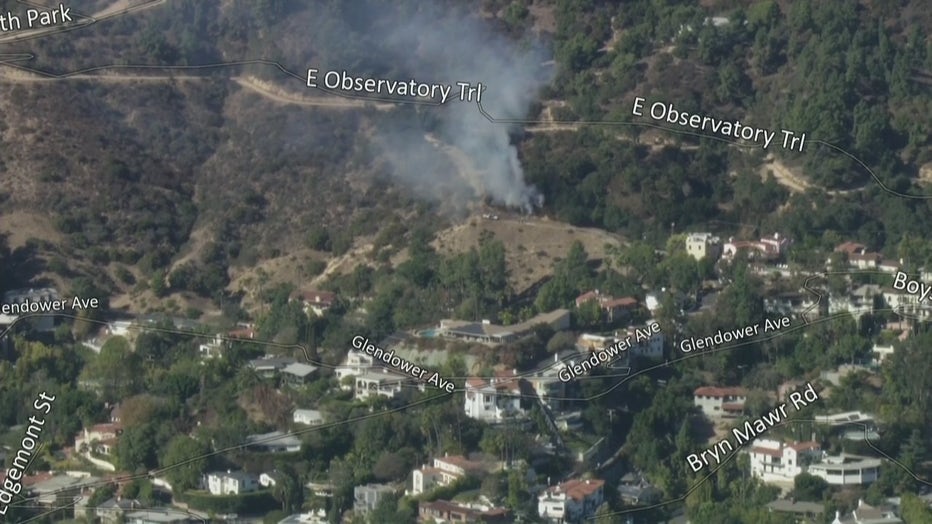
Griffith Fire declared a knockdown
- 1:40 p.m. The Griffith Fire was declared a knockdown shortly after firefighters arrived at the scene. According to LAPD, an alleged arson suspect was arrested nearby after a witness spotted him lighting the fire.

Griffith Park fire quickly knocked down
Los Angeles firefighters were able to quickly knock down a brush fire that erupted Monday afternoon in Griffith Park. Crews are still on scene mopping up hot spots, and the plume of smoke can be seen around the area.
Griffith Fire sparks at Griffith Park
- 1:12 p.m.: A fire, being called the Griffith Fire, erupted in Griffith Park and threatened homes in the area.
Pasadena Drinking Water System Impacted by Eaton Fire
- 1 p.m.: The City of Pasadena issued a do-not-drink water notification alert, applying to tap water, as the area continues dealing with the aftermath of the Eaton Fire. "Bottled water should be used for all drinking (including baby formula and juice), brushing teeth, washing dishes, making ice and food preparation until further notice. This also applies to pets and domestic animals. Additionally, do not try to treat the water yourself. Boiling, freezing, filtering, adding chlorine or other disinfectants, or letting water stand will not make the water safe to drink," city officials said.
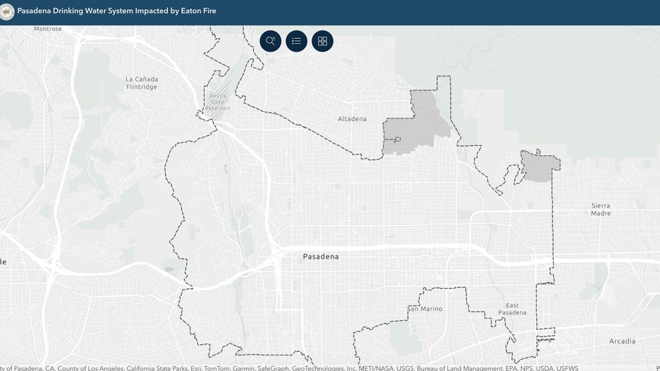
Click here for more information.
Eaton Fire repopulation update
12:08 p.m. Evacuation warnings lifted:
- South of West Harriet Street, East of North Lincoln Avenue, North of West Woodbury Road, West of North Fair Oaks Avenue.
- South of East Harriet Street and East Mendocino Street, East of North Fair Oaks Avenue, North of East Woodbury Road, West of North Lake Avenue
- For those using protect.genasys.com, this zone is listed asALD-WHITEPARK-BALD-CALAVERAS-B
- ALD-WHITEPARK-B
- ALD-CALAVERAS-B
Evacuation orders downgraded to warnings:
- East of North Fair Oaks Avenue, North of East Harriet Street and East Mendocino Street, West of North Lake Avenue South of East Altadena Drive
- East of Sunny Oaks Circle, North of East Altadena Drive, West of Eaton Canyon (Open Space), South of Rubio Canyon
- East of North Lake Avenue, North of East Mendocino Street, West of North Allen Avenue, South of East Altadena Drive
- East of Lincoln Avenue, North of West Harriet Street, West of North Fair Oaks Avenue, South of West Altadena Drive
- For those using protect.genasys.com, these zones are listed asALD-CALAVERAS-AALD-EASTLOMAALD-MENDOCINO-AALD-WHITEPARK-A
- ALD-CALAVERAS-A
- ALD-EASTLOMA
- ALD-MENDOCINO-A
- ALD-WHITEPARK-A
Residents-only:
- East of Lincoln Avenue, North of West Altadena Drive, West of Olive Avenue, South of West Loma Alta Drive
- East of Olive Avenue, North of West Las Flores Drive, West of Fair Oaks Avenue, South of West Loma Alta Drive
- East of Olive Avenue, North of East Altadena Drive, West of North Lake Avenue, South of West and East Las Flores Drive
- East of Fair Oaks Avenue, North of East Las Flores Drive, West of North Marengo Avenue, South of East Loma Alta Drive
- East of North Marengo Avenue, North of East Las Flores Drive, West of North Lake Avenue, South of East Loma Alta Drive
- East of North Lake Avenue, North of Wapello Street and East Palm Street, West of Sunny Oaks Circle, South of The Cobb Estate
- East of North Lake Avenue, North of East Altadena Drive, West of Madison Lane and Crest Drive, South of Wapello Street and East Palm Street
- East of North Sunset Ridge Road, North of West Loma Alta Drive, West of Taos Road, South of Chaney Truck Trail
- East of Taos Road, North of East Loma Alta Drive, West of Altadena Crest Trail, South of Mt Lowe Road
- For those using protect.genasys.com, these zones are listed asALD-GARDENALD-LAURELALD-PALMALD-WAPELLOALD-FARNSWORTHALD-RUBIOALD-MOUNTLOWEALD-CHANEYALD-CANON
- ALD-GARDEN
- ALD-LAUREL
- ALD-PALM
- ALD-WAPELLO
- ALD-FARNSWORTH
- ALD-RUBIO
- ALD-MOUNTLOWE
- ALD-CHANEY
- ALD-CANON
Entry and exit points at the following intersections:
- Altadena Drive and North Fair Oaks Avenue
- West Altadena Drive and Lincoln Avenue
- East Altadena Drive and North Lake Avenue
- West Loma Alta Drive and North Sunset Ridge Road
PDS red flag warning in effect
12:00 p.m.: A ‘Particularly Dangerous Situation’ red flag warning is in effect for most of Southern California.
The warning is in effect until 10 a.m. Tuesday for the Santa Clarita Valley, San Fernando Valley including Calabasas and Agoura Hills, Malibu coast, western Santa Monica Mountains recreation area, the I-5 corridor, San Gabriel Valley and north of the 210 Freeway including Altadena and Glendora.
SUGGESTED: LA Weather Timeline: Santa Ana winds to bring ‘Particularly Dangerous Situation’ Red Flag Warning
Those areas will remain under a standard red flag warning until 10 p.m. Tuesday, with many other areas in the region under warning until 2 p.m. Tuesday.
Forecasters say the area will be in critical fire condition until Thursday. Light rain is expected over the weekend.

LA fires fueled by Santa Ana winds, low humidity
Another Santa Ana wind event moved into the area Monday, with high winds expected into Tuesday, creating a high risk for critical fire weather conditions and rapid fire spread of any new fires. Isolated gusts could reach 50 to 60 mph, according to the National Weather Service.
Update on structures damaged/destroyed
11:45 a.m.: Cal Fire provided new numbers for the Eaton and Palisades Fire.
Palisades Fire
- Structures Threatened: 12,280
- Structures Damaged: 788
- Structures Destroyed: 6,051
Eaton Fire
- Structures Threatened: 8,992
- Structures Damaged: 1,064
- Structures Destroyed: 9,416
Newsom issues executive order
11:40 a.m.: Gov. Gavin Newsom signed an executive order to streamline emergency response work by temporarily suspending certain environmental rules and procedures to allow for faster debris removal and protection against landslides, mudslides, and flash floods.
"As work continues to fight fires across Los Angeles County, the state is already working to prepare for the damage that can happen when winter rainstorms hit burn scars, causing landslides and flooding. This order helps keep our emergency response focused on protecting communities, not permits and paperwork," Newsom said in a statement.
Evacuation Order Lifted for those in the Topanga area
- 11:05 a.m.: An evacuation orders were reduced to resident-only access for residents near Topanga State Park. Residents will have to provide proof of residency with a photo ID that shows a resident’s name, photo and physical address: This includes those who reside:
- North of S. Topanga Boulevard, Summit Drive
- South of North Topanga Canyon Boulevard
- East of Monte Vista Drive
- West of Colina and Waveview drives
‘Extreme fire behavior and weather is probable’

LA fire chief warns of 'extreme wind event'
LAFD Chief Kristin Crowley talks about critical fire weather ahead of a "significant wind event" headed toward Southern California Monday.
- 8:35 a.m. "This is the third significant wind event of the year and we’re very early into this year -- the vegetation is critically dry with relatively humidity nearly 10%...this means if it is ignited, extreme fire behavior and weather is probable," Los Angeles Fire Chief Kristin Crowley said.
Bass: ‘Everyone needs to be on high alert’

LA Mayor: ‘Everyone needs to be on high alert’
With the week starting off with another windstorm, Los Angeles Mayor Karen Bass urges residents to remain on high alert.
- 8:30 a.m.: During a briefing on Monday morning, Los Angeles Mayor Karen Bass warned residents of the wind event and that residents should be prepared to evacuate. She also warned of poor air quality. "Winds could kick up dust and ash in the surrounding areas of the burn site and beyond," she said. She referred to lacity.gov to help residents monitor air quality.
More Eaton Fire evacuees return home
- 7:30 a.m.: As firefighters made progress on the Eaton Fire, more evacuees were allowed to return home. Sadly, many did not have a home to come back to.

Eaton Fire evacuees begin returning home
More people were allowed to return home over the weekend as firefighters made progress with the Eaton Fire.
Overnight updates show progress in the Eaton, Palisades Fires
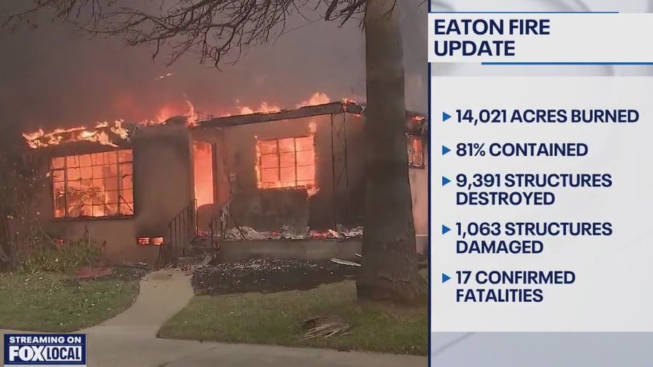
- 6 a.m.: Cal Fire provided new numbers for the Eaton and Palisades Fire
Eaton Fire
- Containment: 87%
- Acres burned: 14,021
Palisades Fire
- Containment: 59%
- Acres burned: 23,713
High winds bring new fire dangers
- 5:45 a.m.: FOX 11'S Gigi Graciette reported on the latest conditions in the Pacific Palisades.

LA wildfires containment updates
- 5:15 a.m.: Numbers from overnight indicate crews made progress on both fires over the weekend. The Palisades Fire is 56% contained and the Eaton Fire is 81% contained.

Santa Ana winds return
5:00 a.m.: Strong Santa Ana winds, which have triggered Red Flag Warnings across Southern California. The windstorm brings the return of hurricane-force winds and extreme fire danger.

Weather Forecast for Monday, Jan. 20
The latest forecast and air quality conditions for the greater Los Angeles area, including beaches, valleys and desert regions.
The Eaton Fire
The Eaton Fire was first reported on Tuesday, Jan. 7 near Altadena and Midwick drives. Some residents did not survive the flames and at least 7,000 structures were destroyed.
Authorities have implemented a curfew from 6 p.m. to 6 a.m. for all areas that remain under mandatory evacuation orders in the Altadena area. This comes after more than 30 looting arrests were made by the LA County Sheriff's Department.
The cause of the fire is under investigation, but they were fueled by extreme drought conditions, combined with the supersized Santa Ana winds that whipped flames and embers at 100 mph – much faster than usual.
A lawsuit filed claims Southern California Edison equipment sparked the Eaton Fire. The lawsuit alleges that Southern California Edison failed to comply with essential electrical and fire safety standards, including failing to maintain power lines and overgrown vegetation.
The Palisades Fire
The Palisades Fire broke out on the afternoon of Tuesday, Jan. 7 as parts of Southern California were hit by powerful Santa Ana winds – the strongest to hit the area in over a decade, officials said. The piercing winds not only intensified the spread of the fire, it also prevented helicopters and planes from dumping water or fire retardant onto the burning scene as it was too dangerous to fly during the first day of the massive fire.
The fire extended well over 23,000 acres in seven days, destroying homes and businesses across the Pacific Palisades and Malibu. The fire also forced evacuations across parts of LA County, including Bel-Air, Brentwood and Santa
Monica. The fire also destroyed the Pacific Palisades Charter High School and other schools in the fire's path.
What caused the Palisades Fire?
The cause of the fire remains under investigation.
According to a report from the Los Angeles Times, a popular hiking destination, Skull Rock – an area north of Sunset Boulevard in Pacific Palisades – is at the center of an investigation "as a possible starting point for the Palisades fire." Meanwhile, local authorities have announced multiple rounds of arrests taking place from the Palisades Fire scenes, but none of which are explicitly related to the cause of the fire. Over the weekend, there was an announcement of a man arrested for impersonating a firefighter. The alleged "fake firefighter" was accused of trying to break into one of the evacuated homes.
Other people have also been accused of arson across Southern California.
Quick Resources
- California Fires Maps: Zones under evacuation orders and warnings
- Shelters, road closures, health alerts, evacuee assistance and more
The Source: Information in this story is from City and County fire officials and previous FOX 11 reports.