

Saturday forecast: Moderate to strong winds return

Saturday forecast: Moderate to strong winds return
Critical fire conditions remain as wind speeds are expected to increase Saturday night and into Sunday, Monday and Tuesday. FOX LA's Maria Quiban has the latest forecast.
More Santa Ana wind events are coming, and both could bring moderate to strong winds to the area, increasing fire danger as wildfires continue to rage.
The Palisades fire flared up and moved east overnight Friday, potentially because of a shift in wind direction, forcing more evacuations and destroying more structures.
RELATED: Palisades Fire spreads toward Encino, Brentwood - more evacuations ordered
"I want you to understand that the fires themselves will create their own weather and atmosphere," FOX LA meteorologist Maria Quiban said. "The bigger they go, the larger what happens. All that air, all that heat that rises. And as that created. And it sucks all that air in from all around it. And that's why sometimes we can notice that the winds are very erratic."
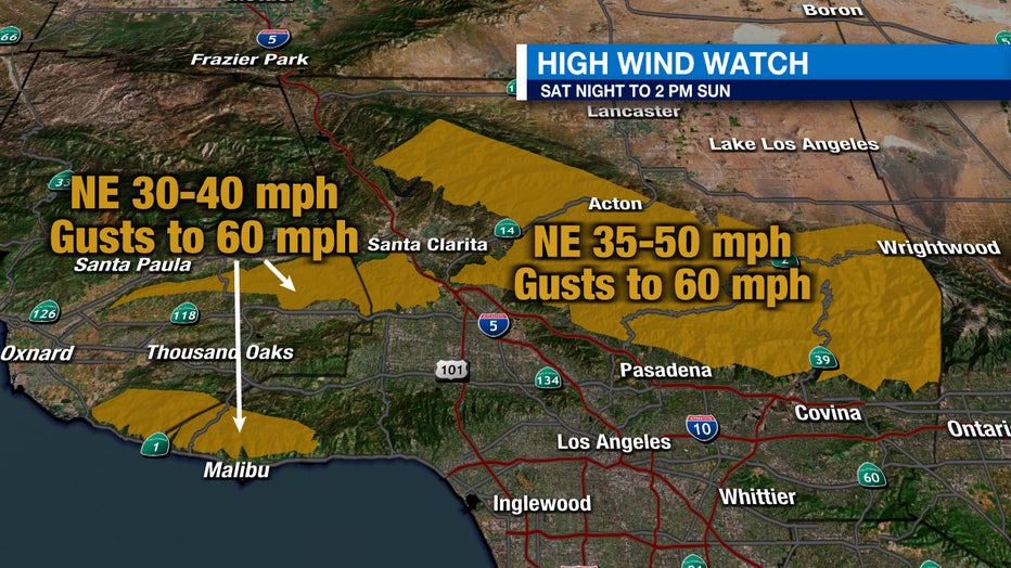
Wind forecast

Palisades Fire: 'Firenado' forms in LA
A small "firenado" has formed as the Palisades Fire continues to spread across Los Angeles County.
Quiban said to expect increasing moderate-strong winds later Saturday.
RELATED: Eaton fire latest: 7,000 structures damaged; progress 'static,' officials say
Although they won’t be as strong as what we saw earlier this week, wind gusts are still expected to get 60-65 mph later tonight and into Sunday, Monday and Tuesday.
Air Quality Alert
Smoke is affecting air quality as far south as Orange County, with some areas reaching levels that are unhealthy for sensitive groups.
Officials on Friday urged residents to remain indoors as much as possible, avoid outdoor physical activity and run air purifiers or AC if you have them.
Red flag warnings

13 missing in California fires
Sheriff Robert Luna on Saturday morning said 11 deaths have been reported in LA County, 8 in the Eaton Fire, three in the Palisades fire, and 13 people are reported missing.
With the Santa Ana winds returning, red flag warnings will remain in place, meaning conditions are critical for fire danger.
RELATED: Fire weather watch vs. red flag warning: What is the difference?
Expect higher winds Saturday night through Sunday morning, and again Monday through Wednesday.
7-day forecast
It’s going to take until Thursday or Friday to see some potential relief. Onshore flow will bring more moisture and a chance for light showers.