

California weather forecast: Timeline for rain across SoCal

California weather: Rain, landslides in SoCal
Southern California is facing rain this weekends, causing problems like mudslides in the area.
LOS ANGELES - A storm is looming in Southern California, anticipated to bring more wet weather, with the heaviest rain expected Sunday into Monday.
"A moist westerly flow pattern will bring periods of precipitation ... with the first round of more significant precipitation around late Saturday and Saturday night," according to the National Weather Service.
The heavy rains will spread south into Southern California from Sunday night into Monday. The heaviest rains are expected on Monday, with thunderstorms possibly adding to the heavy rain potential.

SoCal triple storm threat continues
A series of three storm systems moving across the Southland is expected to bring more rain Sunday and continue on and off through Monday.
Forecasters said through Sunday evening, most areas will receive between .75 and 1.50 inches of rain, and there is a 50% chance for one inch or more of rainfall for portions of the mountains.
The snow level will mostly be above 7,000 feet, but could fall as low as 6,500 feet for late Saturday night, according to the NWS.
The rain was affecting some Southland amusement parks Sunday. Six Flags Magic Mountain was closed Saturday and will also be closed Sunday and Monday, with tickets purchased for those days honored through Dec. 29.
Knott's Berry Farm announced the park closed early at 6 p.m. Saturday due to inclement weather. Unused tickets purchased will be valid until Feb. 25.
Due to the rainfall, the Los Angeles County Department of Public Health advises beach users to avoid all water contact, especially near discharging storm drains, creeks and rivers due to potentially higher bacteria levels in these areas. This includes any runoff that may flow into or pond on the beach sand.
The advisory will be in effect until at least 11 a.m. Tuesday.
Evacuation warnings
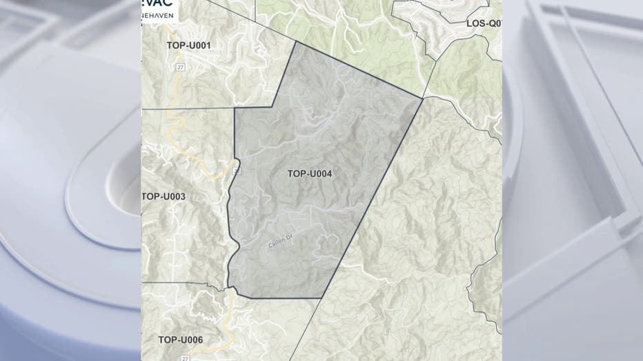
The Los Angeles County Office of Emergency Management issued an Evacuation Warning for a part of Topanga Canyon due to the threat of mudslides and debris flows. The warning effects "Zone 4," which is in the area along Santa Maria Road north of Topanga Canyon Boulevard. The warning will be in effect from 9 p.m. on Jan. 21 through 6 a.m. on Tuesday, Jan. 24.
Officials urged residents in the effected area to continually monitor alertla.org to monitor any warnings or evacuation orders.
Rain timeline
"The second system will move through the area late ... Sunday morning with another `lull' in rain Sunday afternoon and evening. Then finally, the third, and likely most potent, system will move across the area," forecasters said. "This third system will have a bit more instability associated with it. So, there will be a slight chance of thunderstorms for some areas on Monday with rain rates potentially higher than the first two storms."
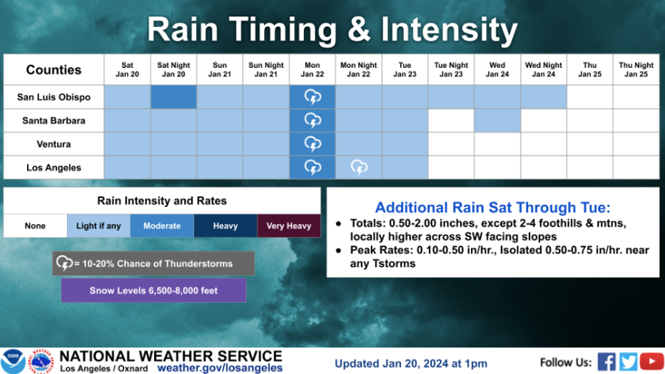
"For the Sunday night through Monday night system, another good rain producer is expected. In this time period, most areas can expect to receive an additional .75 to 1.50 inches of rain," the NWS forecasted.
During this period, most areas can expect to receive an additional .75 to 1.50 inches of rain, the NWS said.
Rain totals
Totals between 1 and 2 inches are expected across coastal and valley areas with 2 to 4 inches across most mountain/foothill areas, according to the weather agency.
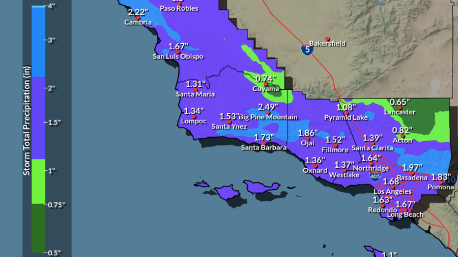
Generally, storm rainfall totals are expected to be around 2 inches in the Los Angeles metro area, with up to 3 inches in the mountains to the north. Even San Diego gets wet, with around 1-1.50 inches of rain expected.
As a result, the WPC has extended a Level 2 out of 4 flash flood risk across coastal Southern California, including Los Angeles and San Diego, on Monday.
Snow totals
Snow levels will be a little bit higher, ranging between 7,000 and 8,000 feet, with any additional snow accumulations being confined to the higher peaks, forecasters said.
High temperatures
"This system does not look like it bring too much in the way of winds. Temperatures will remain on the cool side with cloud cover and the rain," the NWS reported.
High temperatures will be a few degrees either side of 60 in Los Angeles and Orange Counties.
Once the storm moves out, dry conditions are expected for Tuesday through Thursday, and a gradual warming trend can be expected, according to the NWS.
Another atmospheric river approaches the Pacific Coast on Tuesday but will focus more of its rainfall on the Pacific Northwest. The long-range forecasts suggest that additional storms, including potential atmospheric rivers, will keep the West Coast wet by the end of January.
FOX Weather and City News Service contributed to this report.