

Hurricane Lee’s forecast cone includes US cities as East Coast stays on high alert from major storm
With Boston now in the forecast cone, Hurricane Lee remains a large, major hurricane as it moves across the Atlantic Ocean.
Dangerous surf and rip currents along a majority of the U.S. East Coast have started and will worsen as the week continues.
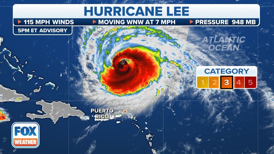
As of the latest advisory from the National Hurricane Center (NHC), Hurricane Lee had maximum sustained winds of 115 mph with some higher gusts, making it a Category 3 on the Saffir-Simpson Hurricane Wind Scale.
And for the first time in Lee's history, land has been included in the forecast cone. Boston and Nantucket, Massachusetts, are both now included in the extreme northwestern edge of the forecast cone.
The powerful storm is moving safely away from the Caribbean Islands, but dangerous surf and life-threatening rip currents have been buffeting the Leeward Islands and Puerto Rico. These conditions will continue spreading to Hispaniola, Turks and Caicos, the Bahamas and Bermuda over the coming days.
The U.S. Coast Guard says sea conditions had deteriorated along Puerto Rico and the U.S. Virgin Islands, with 10-15 foot surf and life-threatening rip currents. The agency says there are particular dangers for those boating, fishing, beachgoing or engaging in water sports.
"We are concerned about people and boaters who may underestimate the impacts of this passing storm," said Capt. José E. Díaz, Coast Guard Sector San Juan (Puerto Rico) commander. "The increase in projected sea states of 10 to 15 feet severely reduces our ability to respond to a maritime distress with the full use of our resources."
Will Lee have any impacts on the US East Coast?
Current infrared satellite loop. (FOX Weather)
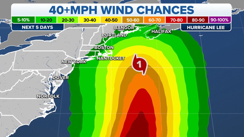
While Lee is expected to move slowly as the steering currents wane, dangerous surf and rip currents are beginning along much of the U.S. Eastern Seaboard and will continue through the week.
Beachgoers on Cape Hatteras, North Carolina, have been warned about the dangerous conditions likely to occur this week.
According to the Cape Hatteras National Seashore Facebook page, visitors are being urged to avoid swimming in the ocean until conditions improve.
"Large breaking waves, life-threatening rip currents, beach erosion, ocean overwash and coastal flooding are all possible," the CHNS said in a Facebook post. " These dangerous conditions are expected to persist into this weekend."
FOX Weather Hurricane Specialist Bryan Norcross said Lee will likely track between the U.S. East Coast and Bermuda, though the exact path to the north is still unclear.
WHAT IS THE 'CONE OF UNCERTAINTY' IN HURRICANE FORECASTS?
Computer models predict Lee will stay offshore of the Eastern Seaboard, and some indicate that the Mid-Atlantic and Northeast coasts may still feel effects from the storm and monitoring future forecasts is recommended.
The jet stream dip is forecast to pass Lee by on Friday, making room for a weak bubble of high pressure north of the hurricane to affect the storm’s path before another dip comes along," Norcross said. "The weak high could deflect Lee toward the New England coast. All this could result in Lee's track having an S-like shape. Although the curves would be slight, as things look right now, any zigging to the left would bring stronger winds near or over the coastline in parts of the Northeast, New England, and Atlantic Canada."
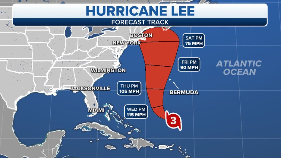
Hurricane Lee Forecast Cone. (FOX Weather)
Hurricane Lee went from Category 1 to Category 5 in 24 hours
The storm underwent rapid intensification with extreme speed on Thursday, transforming from a Category 1 hurricane at 80 mph Wednesday night to a Category 5 monster at 165 mph just 24 hours later.
Lee was only the 13th Category 5 storm to form east of the Caribbean on record.
THESE HURRICANES HAVE ALL UNDERGONE RAPID INTENSIFICATION BEFORE US LANDFALL
The storm ran into wind shear Friday, sapping some of the storm's strength and knocking it down to a Category 3. Lee dropped to a Category 2 storm on Saturday but reenergized into a major hurricane Sunday afternoon. Lee is expected to continue to strengthen as it slowly swirls in the Southwestern Atlantic.
HURRICANE LEE LIVE TRACKER: SATELLITES SPAGHETTI COMPUTER MODELS, CONE OF CONCERN AND MORE
Where Hurricane Lee is. (FOX Weather)
Where is Hurricane Lee?
According to the National Hurricane Center, Hurricane Lee is about 365 miles to the north of the northern Leeward Islands and about 615 miles to the south of Bermuda.
The hurricane continues to head in a northwest direction and has begun slowing down over the southwestern Atlantic. The NHC said Lee could continue to strengthen over the next day or so before gradual weakening begins.
THESE ARE THE STRONGEST HURRICANES IN HISTORY
Hurricane Lee Winds. (FOX Weather)
What is the forecast track for Hurricane Lee?
The NHC says Lee is moving to the northwest near 7 mph, and a slow west-northwest to northwest motion is expected over the next few days, followed by a turn to the north by the middle of the week.
On the current track, Lee is expected to pass near, but to the west, of Bermuda in a few days.
TOP 5 STRONGEST HURRICANES EVER RECORDED IN ATLANTIC BASIN
There are currently no watches or warnings in effect for any landmasses, but the NHC says interests in Bermuda need to monitor the progress of Hurricane Lee.
While Lee had dropped in intensity Friday and early Saturday, forecasters say during the early workweek, the hurricane could regain Category 4 status, if atmospheric conditions are conducive.
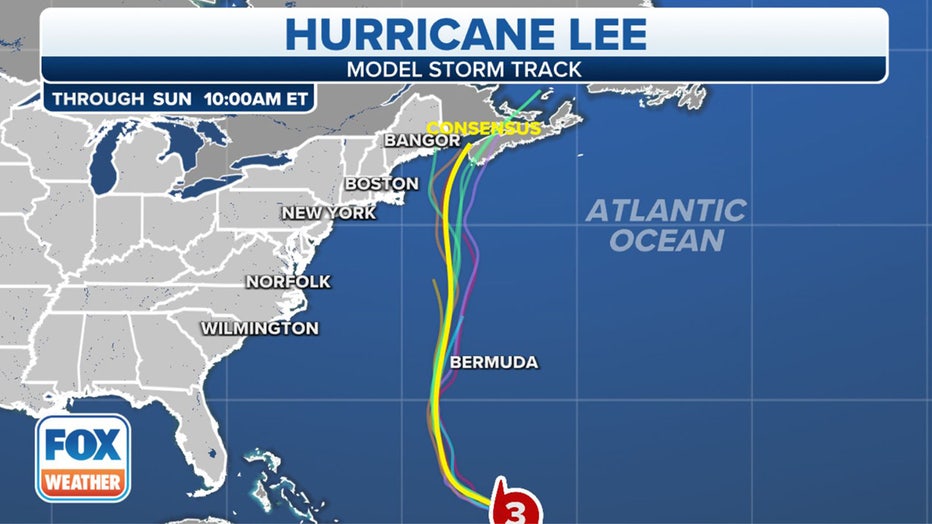
Hurricane Lee Spaghetti Forecast (FOX Weather)