

Weekend storm: What to expect in Southern California

Weather Forecast for Friday, April 12
The latest forecast and air quality conditions for the greater Los Angeles area, including beaches, valleys and desert regions.
LOS ANGELES - After a week filled with sunshine and warm temperatures, a new system is going to cool things off in Southern California. In addition to cooler temperatures, the storm is expected to bring rain that could last through the weekend.
Residents will start to notice the cooler weather accompanied by overcast conditions on Friday.
"The cooling trend will spread throughout the interior by Friday as onshore flow strengthens ahead of another late-season cold upper low dropping south along the West Coast," according to the National Weather Service. "Low clouds and fog will spread into the valleys Friday morning with highs dropping into the 60s to lower 70s."
The storm is forecast to reach the Southland by Saturday morning or afternoon and will make for wet and breezy conditions. Models show most of Southern California will see about a half-inch of rain, with higher rainfall amounts expected in the mountains.
SUGGESTED: Things to do on a rainy weekend in LA
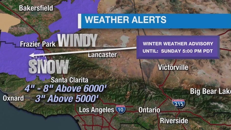
The weekend storm is expected to bring another round of mountain snow. Snow levels were predicted to fall at about 6,000 feet and by Sunday morning, snow levels could drop to as low as 3,500 feet.
NWS issued a Winter Weather Advisory from 11 a.m. to 11 p.m. Saturday for parts of Kern County, which may impact travel along the Grapevine.
The wet weather isn’t expected to last too long and will begin to taper off by late Sunday evening.
The 7-day forecast shows sunny skies and pleasant conditions will return on Monday and will last through the week.
City News Service contributed to this report.