

Southern California threatened by dangerous winds rivaling Category 2 hurricane as Santa Anas return

Santa Ana winds coming to SoCal
High Wind Warnings will go into effect in parts of Southern California starting Thursday FOX 11's Jonathan Novack breaks down what to expect.
California is returning to a dry, warmer break in the weather, but that comes with a moderate to strong Santa Ana wind event that could lead to damaging winds gusting 70-100 mph in areas.
The National Weather Service has much of the state in a checkerboard of Wind Advisories and High Wind Warnings. They go into effect Wednesday evening and will last through Friday morning.
"Damaging winds will blow down trees," the NWS said in its High Wind Warning. "Travel will be difficult, especially for high-profile vehicles. The strongest winds will occur from before sunrise on Thursday into Thursday morning."
The NWS also warned that people should be aware of blowing debris or fallen trees and branches.
"When driving, reduce your speed and be extremely cautious," the NWS continued. "If you encounter fallen electrical wires, do not exit your vehicle."
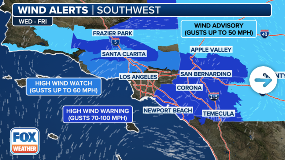
Active wind alerts in Southern California through Friday, March 15, 2024. / FOX Weather
Gusts nearing 100 mph in areas
The hardest hit areas are forecast to be across the Inland Empire, San Bernardino and Riverside County mountains and the valleys and passes through coastal mountains.
"Northeast winds 30 to 40 mph with gusts to 75 mph expected," the NWS office in San Diego posted. "Isolated gusts to around 100 mph for inland Orange County below the coastal slopes of the Santa Ana Mountains and near and below the Cajon Pass."
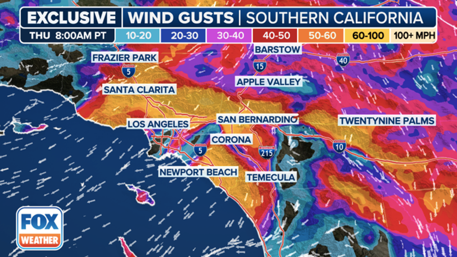
The FOX Model shows winds gusting 50-60 mph over wide stretches of Los Angeles and Orange Counties Thursday morning. / FOX Weather
The FOX Model showed widespread areas of 50-60 mph gusts across much of Los Angeles and Orange Counties. Wind-prone passes and canyons show up to Category 2-hurricane-force gusts are possible.
Sacramento and the San Francisco Bay Area will be spared the worst winds, but will still see gusts to 45-60 mph in the higher hills, according to the NWS. Death Valley is in for gusts to 70 mph and Yosemite Nationla Park to 65 mph. The ridges across the Sierra Nevada should brace for gusts over 100 mph.
The Los Angeles NWS office expects temperatures to warm across the coast and valleys by 3-6 degrees, along with the warm, dry winds. Add that to the sunshine, and temperatures will feel much warmer.
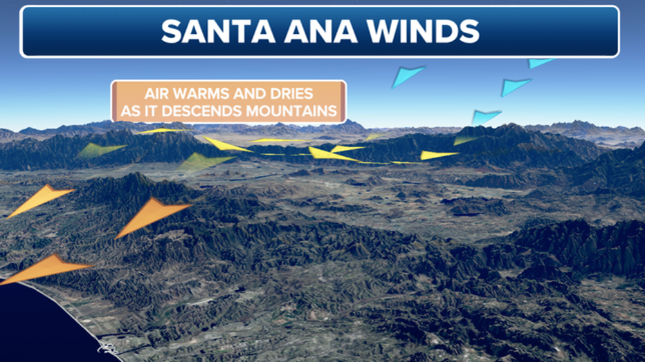
Dry air warms as it flows down mountain faces. / FOX Weather
What's with the change?
After a soggy start to March with storm after storm, high pressure is finally setting up off the coast. This will block any threatening storms. At the same time, a chunk of energy gets separated from the jet stream and parks itself over the Desert Southwest. This is called a cutoff low. The low is bringing colder, denser air into the interior, increasing surface pressures and that difference in pressure between the interior and coastal Southern California is the driving force for the strong wind.
The strong dry winds usually present a high fire risk, but the parade of recent storms dropped enough rain to hopefully keep any sparks in check.
The cutoff low finally drifts farther south Friday, allowing the winds to diminish. Lighter offshore winds will continue through the weekend, though, warming daytime highs 5-10 degrees above normal for this time of year.