

California wildfires recovery updates: Wednesday, Feb. 12

Major storm to slam Southern California
Southern California braced for heavy rain expected to slam the region.
A severe storm making its way into Southern California has triggered concerns of mud and debris flows in areas hit by the Eaton and Palisades fires.
Follow FOX 11's live blog with the latest updates provided on the Jan. 2025 fires in Southern California:
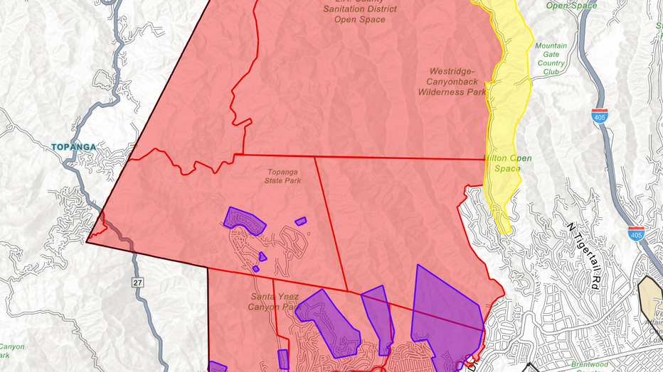
5 p.m.: Evacuation orders have been issued for the following zones in the Pacific Palisades: LOS-0767-A, LOS-0767-B,LOS-0767-D, LOS-0767-E, LOS-0767-I, LOS-0767-J, LOS-0767-K.
4 p.m.: LAFD said evacuation warnings will kick in at 7 a.m. Thursday, Feb. 13 for areas badly hit by the Palisades Fire. Below are the areas that will be under evacuation warnings, but not orders:
- in the Palisades Fire area: the Getty Villa area, Highlands near the burn areas, Bienveneda area near Temescal Canyon Park, Reseda Boulevard area/Marinette Road near Will Rogers State Park, and Mandeville Canyon above Tanners Road;
- in the Sunset Fire area: east and south of Runyon Canyon;
- in the Hurst Fire area: Olive Lane in the Oakridge Mobile Home Park.
Centralized Permit Operation Center opens in West Los Angeles
2:15 p.m.: LA Councilwoman Traci Park announced a Centralized Permit Operation Center has opened in West Los Angeles to help expedite recovery efforts in the Pacific Palisades.
Some resources available at the center include:
- Los Angeles Department of Building and Safety (LADBS)
- Bureau of Street Services
- Bureau of Sanitation
- Department of Transportation
- Los Angeles Department of Water and Power (LADWP)
- Los Angeles Housing Department
- SoCal Gas
- City Planning
- Los Angeles Fire Department (LAFD)
- Bureau of Contract Administration
- Bureau of Engineering
Location: West Los Angeles LADBS Office: 1828 Sawtelle Boulevard, Los Angeles, CA, 90025
Disaster Recovery Centers in LA County
10:00 a.m.: Two Disaster Recovery Centers are open from 9 a.m. to 7 p.m. at the following locations:
- UCLA Research Park: 10850 West Pico Blvd., Los Angeles, CA 90064
- Altadena Disaster Recovery Center: 540 W. Woodbury Road, Altadena, CA 91001
Crews monitoring all burn scar areas within past year
8:30 a.m.: Those living within all burn scar areas within the last year are at-risk, said Mark Pastrella, Director of LA County Public Works.

Crews monitoring multiple burn scar areas
Los Angeles County Public Works Director said crews will monitor all burn scar areas hit within the past year.
LA County Sheriff Robert Luna prepared to use additional resources
8:20 a.m.: Los Angeles County Sheriff Robert Luna said they have additional personnel ready to assist in the affected burn areas and that search and rescue teams, as well as helicopter crews, have been placed on standby.
Homeless outreach teams have also been tasked with asking unsheltered residents in flood-prone areas to relocate.

Sheriff Luna prepared to deploy resources amid storm
Los Angeles County Sheriff Robert Luna said additional personnel are on standby ahead of the incoming storm.
Lindsey Horvath: ‘We are asking everyone to stay alert’
8:10 a.m. Los Angeles County Supervisor Lindsey Horvath said crews have prepared flood control channels and basins across the county. She added they have deployed the necessary resources to address concerns with canyon roads and hillsides along Pacific Coast Highway.
"We’re not experiencing our third story with the most intense projected rains this week, so we are asking everyone to stay alert," she said.

Supervisor Horvath provides updates ahead of storm
Los Angeles County Supervisor Lindsey Horvath provided updates ahead of a projected severe storm headed for Southern California.
LA County Supervisor Kathryn Barger speaks about the seriousness of the storm: ‘Do not risk your life’
8:05 a.m.: Los Angeles County Supervisor Kathryn Barger said clearing debris is one of the crucial steps to recovery.
Those who have been displaced can get personalized resources at the Altadena Disaster Recovery Center located at 540 W. Woodbury Road.
Click here for more information.
She also said those who may become evacuated during the storm should not leave it to chance. "Please heed the evacuation warnings, do not risk your life," she said.
Residents can get updated evacuation information at ready.lacounty.gov.

Barger on incoming storm: 'Do not risk your life'
Los Angeles County Supervisor Kathryn Barger speaks to the seriousness of a severe storm headed for Southern California.
Eaton Fire zone prepares for incoming storm
6:00 a.m.: Residents in the San Gabriel Valley were preparing for an incoming rainstorm that could bring the heaviest rain of the season.

Eaton Fire zones prepares for incoming rainstorm
A severe storm threatens the Eaton Fire zone and could trigger mudslides and flooding.
The Eaton Fire
The Eaton Fire was first reported on Tuesday, Jan. 7 near Altadena and Midwick drives.
Some residents did not survive the flames and at least 7,000 structures were destroyed.
Authorities have implemented a curfew from 6 p.m. to 6 a.m. for all areas that remain under mandatory evacuation orders in the Altadena area. This comes after more than 30 looting arrests were made by the LA County Sheriff's Department.
What caused the Eaton Fire?
The cause of the fire is under investigation, but they were fueled by extreme drought conditions, combined with the supersized Santa Ana winds that whipped flames and embers at 100 mph – much faster than usual.
A lawsuit filed Monday claims Southern California Edison equipment sparked the Eaton Fire.
The lawsuit alleges that Southern California Edison failed to comply with essential electrical and fire safety standards, including failing to maintain power lines and overgrown vegetation.
The Palisades Fire
The Palisades Fire broke out on the afternoon of Tuesday, Jan. 7 as parts of Southern California were hit by powerful Santa Ana winds – the strongest to hit the area in over a decade, officials said. The piercing winds not only intensified the spread of the fire, it also prevented helicopters and planes from dumping water or fire retardant onto the burning scene as it was too dangerous to fly during the first day of the massive fire.
The fire extended well over 23,000 acres in seven days, destroying homes and businesses across the Pacific Palisades and Malibu. The fire also forced evacuations across parts of LA County, including Bel-Air, Brentwood and Santa Monica.
The fire also destroyed the Pacific Palisades Charter High School and other schools in the fire's path.
What caused the Palisades Fire?
The cause of the fire remains under investigation.
According to a report from the Los Angeles Times, a popular hiking destination, Skull Rock – an area north of Sunset Boulevard in Pacific Palisades – is at the center of an investigation "as a possible starting point for the Palisades fire."
Meanwhile, local authorities have announced multiple rounds of arrests taking place from the Palisades Fire scenes, but none of which are explicitly related to the cause of the fire. Over the weekend, there was an announcement of a man arrested for impersonating a firefighter. The alleged "fake firefighter" was accused of trying to break into one of the evacuated homes.
Other people have also been accused of arson across Southern California.