

Los Angeles Rain Timeline: When to expect weekend showers in SoCal

LA Weekend Weather Forecast
After being hit with critical fire weather for weeks, Los Angeles braced for a winter storm that could trigger mudslides.
LOS ANGELES - A significant storm system is set to impact Southern California from Saturday through Monday, bringing widespread rain, mountain snow, and the potential for flooding, according to the National Weather Service (NWS) Los Angeles/Oxnard.
Rain Timeline and Expected Impacts:
Saturday, Jan. 25
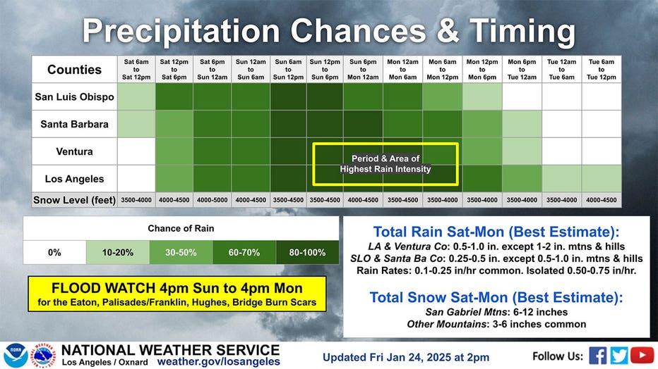
- Light rain will begin in San Luis Obispo and Santa Barbara Counties by mid-morning.
- Precipitation will spread south into Ventura and Los Angeles Counties by the afternoon and evening.
- Snow levels will range from 3,500 to 4,500 feet, affecting mountain travel.
Sunday, Jan. 26
- Rain will increase in coverage and intensity overnight into Sunday morning.
- Moderate to heavy rain is expected throughout the day, particularly in Ventura and Los Angeles Counties.
- Snow levels will rise to 4,000–5,000 feet in the morning, then lower to 3,500–4,000 feet by evening.
- The heaviest rain is expected late Sunday into early Monday, with rain rates of 0.1 to 0.25 inches per hour, and localized rates of up to 0.75 inches per hour.

Residents prepare for weekend storm
A dramatic weather shift is expected in the Southland, highlighted by cooler temperatures and the promise of weekend rain as crews in Pacific Palisades, Altadena and other recent burn areas braced for the possibility of debris flows, forecasters said Saturday.
Monday, Jan. 27
- The storm’s peak intensity will occur from early morning to midday Monday.
- A Flood Watch is in effect from 4 PM Sunday to 4 PM Monday for areas near burn scars, including Eaton, Palisades/Franklin, Hughes, and Bridge.
- Mountain snowfall will range from 6-12 inches in the San Gabriel Mountains and 3-6 inches in other mountain ranges.
- Rain will taper off by Monday evening, with scattered showers lingering into early Tuesday.
Tuesday, Jan. 28
- The storm will exit the region, with only light residual showers possible in the morning.
- Snow levels will rise slightly to 4,000–4,500 feet before drying out.
Rainfall Totals (Saturday–Monday)
- Los Angeles & Ventura Counties: 0.5 to 1 inch, with 1-2 inches in the mountains and hills.
- San Luis Obispo & Santa Barbara Counties: 0.25 to 0.5 inches, with 0.5-1 inch in the mountains.

SoCal prepares for a winter storm
After being hit with critical fire weather for weeks, Los Angeles braced for a winter storm that could trigger mudslides.
Snowfall Totals (Saturday–Monday)
- San Gabriel Mountains: 6-12 inches
- Other Mountain Ranges: 3-6 inches common
Featured

Winter Storm Warning issued for Southern California mountains
A winter storm is expected to bring heavy snow, high winds, and hazardous conditions to the mountains of Southern California starting Saturday afternoon.
Flooding & Travel Hazards
The greatest concern for flooding will be near recent burn scars, where heavy rain could lead to mudslides and debris flows. Travelers in the mountains should prepare for snow-covered roads, chain controls, and possible closures.
Stay updated with the latest forecasts and alerts from the National Weather Service at weather.gov/losangeles.